AtlasCOMPANY SPOTLIGHT
Last updated

Evidence through 30 September 2026 · Prices through 29 September 2026 · Manual updates

Page update only; underlying evidence dates are shown below.
AIM:ARK / ERONGO, NAMIBIA

Arkle ResourcesUranium exploration

Build the evidence bridge from surface to depth.

Four uranium licences. Two distinct exploration styles. A public foundation for a company-reviewed Erongo data room.

UraniumNamibiaPre-resource

PORTFOLIO AT A GLANCE

85%Interest in Namibia Uranium

Reported 29 January 2026

Source ↗
87 holes2,712 m detailed campaign total

Period ended July 2026 · Reported 14 September 2026

Source ↗Source ↗
No MREUranium portfolio pre-resource

Reported 14 September 2026

Source ↗
Source ↗Source ↗
Sources & basis
Acquisition of Namibia Uranium and £1.7m Placing · Extensive Uranium System Defined at ULG Target — Ownership announcement; September detailed campaign and pre-resource status

Public evidence foundation · Company review pending · Market data through 29 September 2026

Project map & source
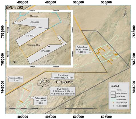
ERONGO / EPL 8995Published plan
Published campaign plan showing the ULG, Paleo East and Paleo West targets
Source figure · no surveyed registration14 Sep 2026
01 / THE PARTNERSHIP OPENING

The opportunity. The evidence still needed.

Opportunity

Arkle’s strongest opening is a campaign room that joins the ULG trenches, drilling, chemical assays and calibrated gamma logs. The public maps already explain where work occurred. The first private transfer can make each result traceable from sample and downhole survey to its interpretation.

  • Trench and surface assays, geological mapping and completed reconnaissance drilling provide several evidence types to test together.
  • Recoverable historical intervals and mapped targets provide a starting point for reviewing the next programme.
Ownership and supporting evidence

85% ownership; obligations separate

Reported 29 January 2026 · Acquisition and contractual terms announced; payment deadlines are contractual, not proof of current unpaid balances

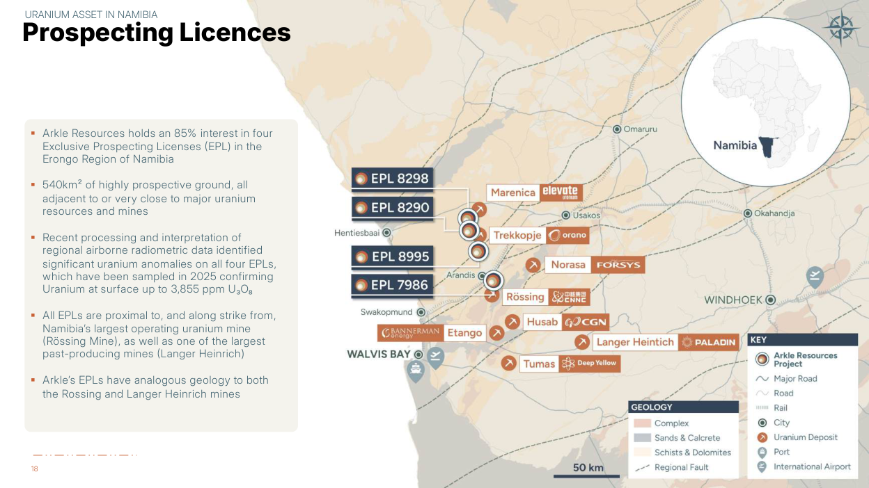
Arkle acquired 85% of Namibia Uranium, holding EPLs 8995, 8290, 8298 and 7986. Retain the 15% minority separately and request its funding/carry rights; the public acquisition summary does not establish a free carry.

Source ↗
Sources & basis
Acquisition of Namibia Uranium and £1.7m Placing — Acquisition and consideration sections

What needs proving

No Mineral Resource has been estimated on these uranium licences. Surface samples, logged leucogranite and visual carnotite cannot establish subsurface uranium grade or continuity. September drilling assays remain pending in the latest recovered disclosure; neighbouring deposits are geological context only.

  • Drilling assays, calibrated gamma interpretation and complete hole records remain unresolved.
  • Current title and approval instruments, acquisition obligations and next-programme funding need dated confirmation.
  • Selected samples, conflicting totals and incomplete coordinate metadata limit what the public evidence can establish.
Evidence limits and unresolved questions

A uranium exploration portfolio

Reported 14 September 2026 · Disclosure date; underlying observation date not separately disclosed

The 14 September announcement expressly says no Mineral Resource has been estimated on any of Arkle’s licences in the uranium discussion. This spotlight does not transfer Stonepark’s separate zinc resource into the uranium portfolio.

Source ↗
Sources & basis
Extensive Uranium System Defined at ULG Target — Deposit Style and Regional Analogues

Campaign and sample reconciliation

Reported 25 June 2026 · 62 collected; 45 submitted on 19 June 2026

Reported 14 September 2026 · September assay populations and selected surface footprint

Reported 16 September 2026 · Later 62-submitted statement; population reconciliation unresolved

Reported 14 September 2026 · Detailed completed programme and host-rock observations

Reported 16 September 2026 · Later approximately 2,900 m summary; unresolved against the 2,712 m detailed total

unresolved

2, 712 m detailed drilling versus around 2, 900 m interim; 1, 558 m palaeochannel drilling versus 1, 559 m logged; “87 vertical” versus inclined ULG holes; 974 samples described ambiguously; 403 combined surface samples versus 242 current field + 178 historical = 420. Do not resolve these by averaging. June 62 collected/45 submitted versus interim 62 submitted; September map 362 versus text 358 ppm. Interim option closing row also inconsistent.

Next evidence: Unique hole and sample manifests with final metres, campaign linkage and QA/QC flags.

Source ↗Source ↗Source ↗
Sources & basis

Complete drill / assay / survey package

issuer data required

Public maps and programme totals recovered; no complete machine-readable collar, downhole survey, assay or geological interval tables.

Next evidence: All 87 modern holes plus legacy database; certified assays and survey control.

Reported 14 September 2026 · Disclosure date; underlying observation date not separately disclosed

Source ↗
Sources & basis

Gamma calibration and disequilibrium

issuer data required

GRS method and sampling threshold disclosed; raw counts, correction/calibration files and eU/chemical comparison unavailable.

Next evidence: Raw gamma channels, processing metadata, calibration pits/standards, borehole correction and disequilibrium tests.

Source ↗
Sources & basis

Underlying technical report

unresolved

Acquisition budgets an updated NI 43-101 report. Issuer site, presentation, archive and targeted searches did not recover the underlying Namibia report. This does not prove it is private or does not exist.

Next evidence: Existing and updated technical reports, authors, dates, referenced historical sources and appendices.

Reported 29 January 2026 · Disclosure date; underlying observation date not separately disclosed

Source ↗
Sources & basis

Current EPL / ECC / ownership instruments

partially closed

8995 dossier recovered: 8026 history, conditional preparedness notice, expired old ECC and mismatched 8024 heritage consent. Current certified titles/ECCs and holder/commodity endorsements remain missing across all four licences.

Next evidence: Current titles, renewal/transfer documents, nuclear-fuel mineral endorsements, conditions, minority and royalty agreements.

Reported 2025 · Disclosure date; underlying observation date not separately disclosed

Reported 2025 · Disclosure date; underlying observation date not separately disclosed

Reported 2022 · Disclosure date; underlying observation date not separately disclosed

Reported 1 August 2023 · Disclosure date; underlying observation date not separately disclosed

Reported 23 August 2023 · Disclosure date; underlying observation date not separately disclosed

Source ↗Source ↗Source ↗Source ↗Source ↗
Sources & basis

Independent geographic control

partially closed

Terrain and satellite align using provider CRS. Exploration drawings remain source-local; Bessel grant versus WGS 84 map and unstated issuer CRS prevent validated overlays.

Next evidence: Native GIS, datum/projection/epoch and at least independent surveyed holdout controls for each drawing; elevation datum.

Reported 1 August 2023 · Disclosure date; underlying observation date not separately disclosed

Reported December 2023 · Disclosure date; underlying observation date not separately disclosed

Reported 14 September 2026 · Disclosure date; underlying observation date not separately disclosed

Source ↗Source ↗Source ↗
Sources & basis
02 / PROJECTS & MATURITY

Pre-resource, with evidence at different stages.

Erongo uranium portfolio

85% interest in Namibia Uranium (Pty) Ltd, which holds four EPLs. Portfolio area is reported as 540 km²; licence-level boundaries and current certificates require confirmation.

Source ↗
Sources & basis
Acquisition of Namibia Uranium and £1.7m Placing — Project overview / tenure discussion

EPL 8995 — Drilling campaign

Drill-tested · assays pending

EPL 8995 • ULG

Source ↗

Reported 14 September 2026 · Disclosure date; underlying observation date not separately disclosed

9 holes · 1,154 m

Next evidence milestone
Receive drilling assays and link them to the trench and lithology records.

Unresolved dependency
Hole-level collars, surveys, final depths and sample records are missing.

Explore evidence
Status, sources & detailed evidence

9 RC holes / 1,154 m; trench/surface assays reported; drilling assays pending

Source date
2026-09-14
Evidence reviewed
Through 30 September 2026
Resource
No resource established
Study
Exploration; no economic study established
Permissions
Current title and environmental approvals require confirmation

9 RC holes / 1,154 m; trench/surface assays reported; drilling assays pending

Permissions: Current licence and environmental-clearance documents required; old submissions are not current approval.

Source ↗
Sources & basis
Extensive Uranium System Defined at ULG Target — ULG drilling and trench sections

Geological evidence, not an inventory

Period ended July 2026 · Completed drilling campaign; precise completion day not disclosed

Reported 14 September 2026 · Detailed completed programme and host-rock observations

Reported 16 September 2026 · Later approximately 2,900 m summary; unresolved against the 2,712 m detailed total

Surface work defines a reported ULG footprint about 1.5 km by 0.6 km. Drilling logs indicate leucogranite to about 188 m below surface. The depth describes host rock occurrence; it is not a uranium-grade interval, and the footprint is not a tonnage estimate.

Source ↗
Sources & basis
Extensive Uranium System Defined at ULG Target — Trenching; Deposit Style; ULG Drill Holes

Trench and surface assays

Reported 14 September 2026 · Sampling, laboratory results or interpretation; exact individual observation dates not disclosed

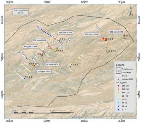
14 trenches total 1,973 m; the analytical batch includes 213 trench samples, 29 nearby surface samples and 29 QA/QC inserts (271 total). Peak reported results are 358 ppm U₃O₈ in trenches and 800 ppm in a surface pavement sample. Selective results are not bulk deposit grades.

Source ↗
Sources & basis
Extensive Uranium System Defined at ULG Target — Trenching, Mapping and Surface Geochemistry

Assays and gamma estimates stay separate

Reported 14 September 2026 · Sampling, laboratory results or interpretation; exact individual observation dates not disclosed

The issuer converts laboratory elemental U to U₃O₈ using 1.17924. Equivalent uranium (eU₃O₈) derives from gamma measurements and requires calibration and disequilibrium assessment. The 40 ppm eU₃O₈ threshold selected samples; it is not a resource cut-off.

Source ↗
Sources & basis
Extensive Uranium System Defined at ULG Target — Assay conversion; Paleochannel Drilling; downhole spectrometry

Campaign total

Period ended July 2026 · Completed drilling campaign; precise completion day not disclosed

Reported 14 September 2026 · Detailed completed programme and host-rock observations

Reported 16 September 2026 · Later approximately 2,900 m summary; unresolved against the 2,712 m detailed total

The detailed 14 September breakdown is 87 holes / 2,712 m: ULG 9 / 1,154 m; Paleo East 66 / 1,390 m; Paleo West 12 / 168 m. The interim’s “around 2,900 metres” is inconsistent; use the detailed total pending company reconciliation.

Source ↗Source ↗
Sources & basis
Extensive Uranium System Defined at ULG Target · Interim Results — 14 September drill breakdown; 16 September highlights

Do not model 87 vertical holes

Period ended July 2026 · Completed drilling campaign; precise completion day not disclosed

Reported 14 September 2026 · Detailed completed programme and host-rock observations

Reported 16 September 2026 · Later approximately 2,900 m summary; unresolved against the 2,712 m detailed total

The announcement initially calls the programme vertical, but later gives ULG dips of −60° to −90° and downhole deviation surveys for only four ULG holes. Per-hole collars, orientations and surveys are missing, so this demo creates no downhole traces.

Source ↗
Sources & basis
Extensive Uranium System Defined at ULG Target — Paleochannel Drilling versus ULG Drill Holes Completed

Assays still pending in the recovered record

Reported 14 September 2026 · No drilling assays received

Target announced 16 September 2026 · Results expected within the next 20 days; a forecast, not receipt of results

On 14 September no drilling assays had been received. The 16 September interim expected results within the next 20 days. No later assay release was recovered by the cutoff search; an expected reporting window is not an assay result.

Source ↗Source ↗
Sources & basis
Extensive Uranium System Defined at ULG Target · Interim Results — Downhole assays statement; CEO interim comment

Selected assays do not describe an average grade

Reported 25 June 2026 · 62 collected; 45 submitted on 19 June 2026

Reported 14 September 2026 · September assay populations and selected surface footprint

Reported 16 September 2026 · Later 62-submitted statement; population reconciliation unresolved

September reports 39 results >100 ppm U₃O₈, 26 from trenches; 13 >200 ppm, five from trenches. The 077° corridor (1, 140×91 m) uses a 200 ppm selection threshold. It is a selected surface footprint, not a resource envelope. Earlier June work collected 62 trench samples but submitted 45 on 19 June with controls; the interim describes 62 submitted. Recover the dispatch manifest before equating collected, submitted and reported populations.

Source ↗Source ↗Source ↗
Sources & basis

Figure labels retain their own values

Reported 14 September 2026 · Sampling, laboratory results or interpretation; exact individual observation dates not disclosed

The September ULG map labels an eastern point 362 ppm U₃O₈, while the text reports 358 ppm as the trench maximum and the figure includes an 800 ppm callout. The map also labels 358 elsewhere. The reconstruction retains source categories and treats point identities/sample types as unknown where not explicitly linked; it does not silently reconcile 362 with 358. The 362 ppm point may be a surface result; this is a sample-linkage question, not a demonstrated error in the trench maximum.

Source ↗
Sources & basis
Extensive Uranium System Defined at ULG Target — Second figure versus Trenching prose

8026 →8995: history supported, current title unresolved

As at 1 August 2023 · Preparedness notice acceptance; not an issued title

Reported 18 December 2023 · Historical environmental report

The December 2023 environmental report says EPL 8026 was re-registered as 8995 for nuclear commodities. The attachment called “MME Grant” is a notice of preparedness to grant, accepted 1 August 2023, with environmental prerequisites before issuance. Its three-year term is tied to ECC issuance. It is not proof of a current issued or transferred title.

Source ↗Source ↗
Sources & basis

The dossier is not a current approval pack

As at 17 October 2022 · Old 8026 certificate issued; expiry 17 October 2025

As at 23 August 2023 · Unrelated 8024 heritage consent; expiry 22 August 2024

Reported 19 January 2024 · Application screening only

The old certificate names 8026 and ran 17 October 2022–17 October 2025. January 2024 screening verifies the application and requests documents; it does not grant clearance. The attached heritage consent 119/2023/135 names EPL 8024/Parkland Energy Resources and expired 22 August 2024, so it cannot evidence 8995 heritage consent. No adverse compliance finding is inferred from missing current records.

Source ↗Source ↗Source ↗
Sources & basis

Two coordinate references cannot be merged by appearance

Reported 1 August 2023 · Bessel reference in historical notice

Reported December 2023 · WGS84 site map

Reported 14 September 2026 · Issuer map with incomplete CRS metadata

The grant attachment specifies Bessel 1841 and Albers Conic Equal Area (central meridian 17°E); the December 2023 site map specifies GCS WGS 1984. Issuer ULG map grid numbers lack a complete CRS statement. Native digitisation stays in source pixels and its grid fit is internal only; no surveyed-coordinate or current-boundary accuracy is claimed.

Source ↗Source ↗Source ↗
Sources & basis
Source ↗
Sources & basis

Extensive Uranium System Defined at ULG Target — ULG drilling and trench sections

Drilled · chemical validation pending

EPL 8995 • Paleo East

Source ↗

Reported 14 September 2026 · Disclosure date; underlying observation date not separately disclosed

66 holes · 1,390 m

Next evidence milestone
Reconcile modern samples with the historical gamma intervals.

Unresolved dependency
Calibrated gamma, chemical assays and historical hole identities remain incomplete.

Explore evidence
Status, sources & detailed evidence

66 holes / 1,390 m; shallow palaeochannel exploration

Source date
2026-09-14
Evidence reviewed
Through 30 September 2026
Resource
No resource established
Study
Exploration; no economic study established
Permissions
Current title and environmental approvals require confirmation

66 holes / 1,390 m; shallow palaeochannel exploration

Permissions: Current licence and environmental-clearance documents required; old submissions are not current approval.

Source ↗
Sources & basis
Extensive Uranium System Defined at ULG Target — Eastern paleochannel drilling

Palaeochannel sampling

Reported 14 September 2026 · Sampling, laboratory results or interpretation; exact individual observation dates not disclosed

Paleo East contributes 21 holes and 196 samples selected from gamma response; Paleo West contributes one hole and eight samples. Combined palaeochannel sampling is 204, plus approximately 10% QA/QC inserts. All 78 palaeochannel holes are reported as vertical.

Source ↗
Sources & basis
Extensive Uranium System Defined at ULG Target — Eastern and Western Paleochannel Target Drilled
Source ↗
Sources & basis

Extensive Uranium System Defined at ULG Target — Eastern paleochannel drilling

Drilled · interpretation pending

EPL 8995 • Paleo West

Source ↗

Reported 14 September 2026 · Disclosure date; underlying observation date not separately disclosed

12 holes · 168 m

Next evidence milestone
Test the palaeochannel interpretation against assays and logged intervals.

Unresolved dependency
Visual mineralogy does not establish uranium grade or continuity.

Explore evidence
Status, sources & detailed evidence

12 holes / 168 m; palaeochannel exploration

Source date
2026-09-14
Evidence reviewed
Through 30 September 2026
Resource
No resource established
Study
Exploration; no economic study established
Permissions
Current title and environmental approvals require confirmation

12 holes / 168 m; palaeochannel exploration

Permissions: Current licence and environmental-clearance documents required; old submissions are not current approval.

Source ↗
Sources & basis
Extensive Uranium System Defined at ULG Target — Western paleochannel drilling

Visual geology is not a grade

Reported 14 September 2026 · Sampling, laboratory results or interpretation; exact individual observation dates not disclosed

Carnotite was visually logged in six holes across eight intervals at downhole depths of 1–22 m. Chemical assays are needed to establish uranium content. Keep logged mineralogy separate from analytical and radiometric results.

Source ↗
Sources & basis
Extensive Uranium System Defined at ULG Target — Paleochannel Lithology and Mineralisation
Source ↗
Sources & basis

Extensive Uranium System Defined at ULG Target — Western paleochannel drilling

Further Erongo licences

Target generation

EPL 8290

Source ↗

Reported 22 May 2026 · Disclosure date; underlying observation date not separately disclosed

Geophysics + surface evidence

Next evidence milestone
Rank mapped anomalies using complete coverage and follow-up sampling.

Unresolved dependency
Survey data, target identities and ground validation remain incomplete.

Explore evidence
Status, sources & detailed evidence

Geophysical / surface targets; no separate modern drill result established

Source date
2026-05-22
Evidence reviewed
Through 30 September 2026
Resource
No resource established
Study
Exploration; no economic study established
Permissions
Current title and environmental approvals require confirmation

Geophysical / surface targets; no separate modern drill result established

Permissions: Current licence and environmental-clearance documents required; old submissions are not current approval.

Source ↗
Sources & basis
Uranium Targets Defined; Drilling Accelerated — Phase 1 interpretation and further targets

Targets beyond EPL 8995

Reported 22 May 2026 · Disclosure date; underlying observation date not separately disclosed

The May interpretation integrates airborne magnetics/radiometrics, HLEM and 2025 geochemistry across 8995, 8290 and 8298. Further mapping, sampling and geophysics were planned to develop other targets. No licence-level resource or economic case follows from those targets.

Source ↗
Sources & basis
Uranium Targets Defined; Drilling Accelerated — Phase 1 results and next steps

2025 campaign

Period ended 2025 · 2025 sampling campaign; exact sampling dates not disclosed

Reported 29 January 2026 · 178 samples and selected sample maxima

The acquisition describes 178 samples from pits about 0.35–0.5 m deep. Combined 8995/8290 maxima were 2,782 ppm U₃O₈ in calcrete and 3,855 ppm in alaskite candidates. Preparation and multi-element analysis are described, but native sample records and QA/QC results are missing.

Source ↗
Sources & basis
Acquisition of Namibia Uranium and £1.7m Placing — About Namibia Uranium; 2025 sampling and laboratory method

Survey resolution and coverage matter

Target announced 23 February 2026 · Four planned HLEM profiles

Reported 1 April 2026 · Completed airborne survey and three HLEM profiles; historical government survey date not disclosed

Reported 22 May 2026 · Later interpretation

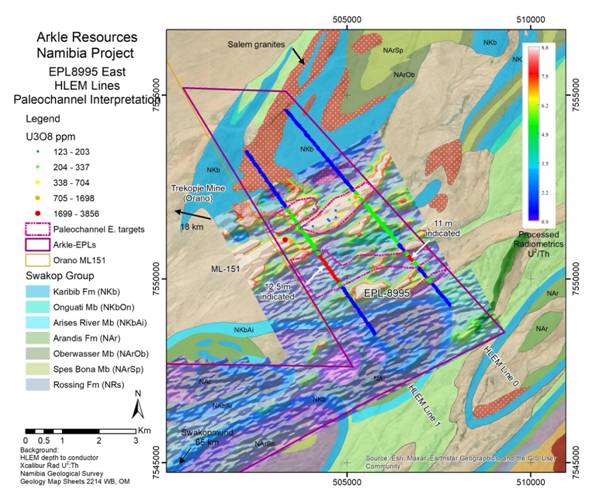
The completed airborne programme was 12, 376 line-km at 50 m line spacing, compared with 200 m historical government data. April reports three completed HLEM profiles; February 23 had planned four. Northern 8995/8290/8298 coverage must not be transferred to 7986. Radiometric response mainly constrains near-surface uranium and HLEM conductivity supports an interpreted channel geometry; neither establishes uranium grade or mineralised thickness.

Source ↗Source ↗Source ↗
Sources & basis
Company Updates · Uranium Updates - Geophysical Surveys Complete · Uranium Targets Defined; Drilling Accelerated — Planned work, completed surveys and Phase 1 interpretation

Anomaly count needs a feature register

Reported 22 May 2026 · Disclosure date; underlying observation date not separately disclosed

May describes four prominent eastern 8290 uranium anomalies; its detailed U/Th discussion confirms three, while the headline implies all four. Preserve both statements. Western anomalies and central palaeochannel extents are targets, not resources.

Source ↗
Sources & basis
Uranium Targets Defined; Drilling Accelerated — Phase 1 highlights versus Targeting Other Paleochannels
Source ↗
Sources & basis

Uranium Targets Defined; Drilling Accelerated — Phase 1 interpretation and further targets

Target generation

EPL 8298

Source · p. 1 ↗

Reported 12 May 2025 · Disclosure date; underlying observation date not separately disclosed

Regional maps + waypoints

Next evidence milestone
Reconcile environmental waypoints, exploration targets and current tenure.

Unresolved dependency
Published waypoints are not surveyed collars; current permissions remain unconfirmed.

Explore evidence
Status, sources & detailed evidence

Geophysical / surface targets; 2025 environmental target waypoints recovered

Source date
2025
Evidence reviewed
Through 30 September 2026
Resource
No resource established
Study
Exploration; no economic study established
Permissions
Current title and environmental approvals require confirmation

Geophysical / surface targets; 2025 environmental target waypoints recovered

Permissions: Current licence and environmental-clearance documents required; old submissions are not current approval.

Source · p. 1 ↗
Sources & basis

106 legacy holes, separate from modern drilling

Reported 1 April 2026 · 95 accessible historical holes

Reported 22 May 2026 · About 50 of 95 planned holes logged

Reported 25 June 2026 · 106 historical holes logged; original drilling dates not disclosed

April identified 95 accessible historical holes; May had logged about 50 of 95 planned. June reports 106 legacy holes logged across EPL 8995 and 8298 with a four-channel spectrometer. Sixteen returned >50 ppm eU₃O₈ over ≥1 m and seven >100 ppm. Original operators, collars and analytical provenance remain unresolved; neither the 95 nor 106 is the modern 87-hole programme.

Source ↗Source ↗Source ↗
Sources & basis

Public government-submission coordinates

Reported 12 May 2025 · EMP cover release date for both waypoint tables; field observation dates not disclosed

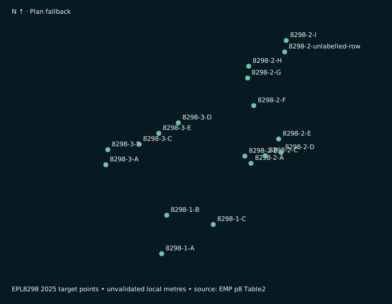
The May 2025 EPL 8298 EMP lists 18 target waypoints in three clusters; the 7986 EMP lists nine. They are exploration target points, not certified assays or drill collars. Coordinate datum is not explicitly attached to the tables; use source-local coordinate views until surveyed control is supplied.

Source · p. 8 ↗Source · p. 8 ↗
Sources & basis

Old certificate is not current approval

As at 2 November 2022 · 8298 historical certificate issued; expired 2 November 2025

As at 18 August 2025 · 7986 historical certificate expiry; no current approval established

Reported 12 May 2025 · Renewal/amendment submission dates

The recovered old EPL 8298 environmental certificate was issued 2 November 2022 and expired 2 November 2025; EPL 7986’s expired 18 August 2025. The 2025 documents are renewal/amendment submissions. Current certificates and holder/commodity endorsements have not been independently recovered.

Source ↗Source ↗Source ↗Source ↗
Sources & basis

Government map has internal inconsistencies

Reported 12 May 2025 · EMP release date, not a current title verification

The 8298 EMP locality map labels neighbouring EPL 8026 rather than current portfolio EPL 8995, and labels a metre-like grid as decimal degrees. Preserve the source figure as historical context; do not use it as a current legal boundary or geographic registration control.

Source · p. 9 ↗
Sources & basis
Source · p. 1 ↗
Sources & basis
Early surface target

EPL 7986 • North Rössing

Source · p. 21 ↗

Reported 2 April 2026 · Disclosure date; underlying observation date not separately disclosed

North Rössing

Next evidence milestone
Validate selected historical surface results and map geological controls.

Unresolved dependency
Sample representativeness, current tenure and the 2,924/2,923 ppm discrepancy remain unresolved.

Explore evidence
Status, sources & detailed evidence

Selective historical surface samples; early primary uranium target

Source date
2026-04-02
Evidence reviewed
Through 30 September 2026
Resource
No resource established
Study
Exploration; no economic study established
Permissions
Current title and environmental approvals require confirmation

Selective historical surface samples; early primary uranium target

Permissions: Current licence and environmental-clearance documents required; old submissions are not current approval.

Source · p. 21 ↗
Sources & basis

North Rössing remains its own early target

Reported 29 January 2026 · Selected historical samples; sampling dates not disclosed

Reported 2 April 2026 · Presentation values and selected subset; not a new resource estimate

The acquisition and presentation tabulate 500–2,923 ppm U₃O₈ across selected 7986 samples. Presentation p23 instead highlights a 2,480 ppm subset. Do not silently replace one maximum with the other or infer deposit scale from proximity to Rössing.

Source ↗Source · p. 21 ↗
Sources & basis
Source · p. 21 ↗
Sources & basis
03 / EXPLORE THE EVIDENCE

Explore Erongo’s evidence.

Display
Navigate
Frame
Loading evidence scene…
Layers & appearance

Layer visibility

Appearance

Sources, methods & downloads

Scroll vertically to zoom at the pointer; horizontally or with Shift to pan. Drag uses Pan or Orbit. Pinch zooms. Arrow keys move; + / − zoom. Esc closes expanded view.

Reported 14 September 2026 · Shared date for the trench metrics below; sampling dates not disclosed

14 trenches1,973 m total
1–1.5 mReported excavation depth
255 stationsGeology mapped on floors and walls
213 samplesTrench field samples
29 samplesNearby surface field samples
29 insertsQA/QC; 271 analytical entries total

September 2026: 26 trench samples exceeded 100 ppm U₃O₈; five exceeded 200 ppm. Reported maxima: 358 ppm in trench samples and 800 ppm in a surface pavement sample. Selected results are not average deposit grades. ULG was logged at 48 of 255 geological stations; full station and channel logs were not recovered.

Source ↗
Sources & basis

Extensive Uranium System Defined at ULG Target — Trenching, Mapping and Surface Geochemistry

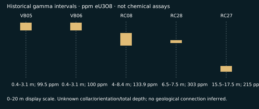
HISTORICAL DRILLING · JUNE 2026 GAMMA SURVEY

Reported intervals, on a shared depth scale

Five named intervals recovered. These are downhole depth logs, linked to recovered source-map symbols where available; they are not underground trajectories. Grey dashed guides indicate the display scale; they do not assert total hole depth or barren ground.

Reported 25 June 2026 · Historical gamma-derived intervals; original drilling dates not disclosed

Select a column to read its interval and evidence limits. Gamma-derived uranium estimates remain subject to chemical validation.

Hole register CSV · Hole register JSON · Depth-log SVG · June primary announcement ↗

Why the modern holes are not underground traces yet

The ULG campaign reports nine holes, depths of 70–200 m and dips of −60° to −90°, with four deviation surveys. Individual collar, elevation, orientation, total-depth and survey rows were not recovered. Programme ranges cannot be assigned to named holes. The map symbols remain selectable while those fields remain null in the hole register.

Accessible evidence tables & source figures

The tables and original figures remain usable without the 3D renderer. Flat map planes do not imply terrain or a subsurface model.

Open accessible plan SVG

Source-linked plan fallback

campaignTotals

Download CSV

Dated evidence · Shared disclosure: 14 September 2026
idholesmetresresultStateEvidenceDate & basis
ULG91154Drill chemical assays pending
Sources & basis

Reported 14 September 2026 · Disclosure date; underlying observation date not separately disclosed

Source ↗
Paleo East661390Drill chemical assays pending
Sources & basis
Extensive Uranium System Defined at ULG Target — Eastern Paleochannel Target Drilled

Reported 14 September 2026 · Disclosure date; underlying observation date not separately disclosed

Source ↗
Paleo West12168Drill chemical assays pending
Sources & basis
Extensive Uranium System Defined at ULG Target — Western Paleochannel Target Drilled

Reported 14 September 2026 · Disclosure date; underlying observation date not separately disclosed

Source ↗

targetWaypoints

Download CSV

Dated evidence · Dates below distinguish source disclosures from observation periods
idlicencesourceLabellatitudelongitudedatumtypeelevationdateEvidenceDate & basis
8298-1-A82981-A-22.03619114.86962Not explicit on coordinate table; unvalidatedHistorical exploration target waypoint, not assay or collar—2025-05-12
Sources & basis

Reported 12 May 2025 · Date recorded in source; not a new survey or current title verification

Source · p. 8 ↗
8298-1-B82981-B-22.03419814.869904Not explicit on coordinate table; unvalidatedHistorical exploration target waypoint, not assay or collar—2025-05-12
Sources & basis

Reported 12 May 2025 · Date recorded in source; not a new survey or current title verification

Source · p. 8 ↗
8298-1-C82981-C-22.03467814.872503Not explicit on coordinate table; unvalidatedHistorical exploration target waypoint, not assay or collar—2025-05-12
Sources & basis

Reported 12 May 2025 · Date recorded in source; not a new survey or current title verification

Source · p. 8 ↗
8298-2-A82982-A-22.03151314.874611Not explicit on coordinate table; unvalidatedHistorical exploration target waypoint, not assay or collar—2025-05-12
Sources & basis

Reported 12 May 2025 · Date recorded in source; not a new survey or current title verification

Source · p. 8 ↗
8298-2-B82982-B-22.03113914.874271Not explicit on coordinate table; unvalidatedHistorical exploration target waypoint, not assay or collar—2025-05-12
Sources & basis

Reported 12 May 2025 · Date recorded in source; not a new survey or current title verification

Source · p. 8 ↗
8298-2-C82982-C-22.03111614.875401Not explicit on coordinate table; unvalidatedHistorical exploration target waypoint, not assay or collar—2025-05-12
Sources & basis

Reported 12 May 2025 · Date recorded in source; not a new survey or current title verification

Source · p. 8 ↗
8298-2-D82982-D-22.03094914.876294Not explicit on coordinate table; unvalidatedHistorical exploration target waypoint, not assay or collar—2025-05-12
Sources & basis

Reported 12 May 2025 · Date recorded in source; not a new survey or current title verification

Source · p. 8 ↗
8298-2-E82982-E-22.03025414.876158Not explicit on coordinate table; unvalidatedHistorical exploration target waypoint, not assay or collar—2025-05-12
Sources & basis

Reported 12 May 2025 · Date recorded in source; not a new survey or current title verification

Source · p. 8 ↗
8298-2-F82982-F-22.02852514.874768Not explicit on coordinate table; unvalidatedHistorical exploration target waypoint, not assay or collar—2025-05-12
Sources & basis

Reported 12 May 2025 · Date recorded in source; not a new survey or current title verification

Source · p. 8 ↗
8298-2-G82982-G-22.02709514.874425Not explicit on coordinate table; unvalidatedHistorical exploration target waypoint, not assay or collar—2025-05-12
Sources & basis

Reported 12 May 2025 · Date recorded in source; not a new survey or current title verification

Source · p. 8 ↗
8298-2-H82982-H-22.02648614.874484Not explicit on coordinate table; unvalidatedHistorical exploration target waypoint, not assay or collar—2025-05-12
Sources & basis

Reported 12 May 2025 · Date recorded in source; not a new survey or current title verification

Source · p. 8 ↗
8298-2-I82982-I-22.02515414.876579Not explicit on coordinate table; unvalidatedHistorical exploration target waypoint, not assay or collar—2025-05-12
Sources & basis

Reported 12 May 2025 · Date recorded in source; not a new survey or current title verification

Source · p. 8 ↗
8298-2-unlabelled-row82982-unlabelled-row-22.02574314.876494Not explicit on coordinate table; unvalidatedHistorical exploration target waypoint, not assay or collar—2025-05-12
Sources & basis

Reported 12 May 2025 · Date recorded in source; not a new survey or current title verification

Source · p. 8 ↗
8298-3-A82983-A-22.03158914.866499Not explicit on coordinate table; unvalidatedHistorical exploration target waypoint, not assay or collar—2025-05-12
Sources & basis

Reported 12 May 2025 · Date recorded in source; not a new survey or current title verification

Source · p. 8 ↗
8298-3-B82983-B-22.03080614.86661Not explicit on coordinate table; unvalidatedHistorical exploration target waypoint, not assay or collar—2025-05-12
Sources & basis

Reported 12 May 2025 · Date recorded in source; not a new survey or current title verification

Source · p. 8 ↗
8298-3-C82983-C-22.03052514.868364Not explicit on coordinate table; unvalidatedHistorical exploration target waypoint, not assay or collar—2025-05-12
Sources & basis

Reported 12 May 2025 · Date recorded in source; not a new survey or current title verification

Source · p. 8 ↗
8298-3-D82983-D-22.02941514.87055Not explicit on coordinate table; unvalidatedHistorical exploration target waypoint, not assay or collar—2025-05-12
Sources & basis

Reported 12 May 2025 · Date recorded in source; not a new survey or current title verification

Source · p. 8 ↗
8298-3-E82983-E-22.02996214.869459Not explicit on coordinate table; unvalidatedHistorical exploration target waypoint, not assay or collar—2025-05-12
Sources & basis

Reported 12 May 2025 · Date recorded in source; not a new survey or current title verification

Source · p. 8 ↗
7986-A7986A-22.45812715.073486Not explicit on coordinate table; unvalidatedHistorical exploration target waypoint, not assay or collar—2025-05-12
Sources & basis

Reported 12 May 2025 · Date recorded in source; not a new survey or current title verification

Source · p. 8 ↗
7986-B7986B-22.45874615.073584Not explicit on coordinate table; unvalidatedHistorical exploration target waypoint, not assay or collar—2025-05-12
Sources & basis

Reported 12 May 2025 · Date recorded in source; not a new survey or current title verification

Source · p. 8 ↗
7986-C7986C-22.45907415.075972Not explicit on coordinate table; unvalidatedHistorical exploration target waypoint, not assay or collar—2025-05-12
Sources & basis

Reported 12 May 2025 · Date recorded in source; not a new survey or current title verification

Source · p. 8 ↗
7986-D7986D-22.45624315.078148Not explicit on coordinate table; unvalidatedHistorical exploration target waypoint, not assay or collar—2025-05-12
Sources & basis

Reported 12 May 2025 · Date recorded in source; not a new survey or current title verification

Source · p. 8 ↗
7986-E7986E-22.45543315.078349Not explicit on coordinate table; unvalidatedHistorical exploration target waypoint, not assay or collar—2025-05-12
Sources & basis

Reported 12 May 2025 · Date recorded in source; not a new survey or current title verification

Source · p. 8 ↗
7986-F7986F-22.45503615.078387Not explicit on coordinate table; unvalidatedHistorical exploration target waypoint, not assay or collar—2025-05-12
Sources & basis

Reported 12 May 2025 · Date recorded in source; not a new survey or current title verification

Source · p. 8 ↗
7986-G7986G-22.45428215.079776Not explicit on coordinate table; unvalidatedHistorical exploration target waypoint, not assay or collar—2025-05-12
Sources & basis

Reported 12 May 2025 · Date recorded in source; not a new survey or current title verification

Source · p. 8 ↗
7986-H7986H-22.45324615.080159Not explicit on coordinate table; unvalidatedHistorical exploration target waypoint, not assay or collar—2025-05-12
Sources & basis

Reported 12 May 2025 · Date recorded in source; not a new survey or current title verification

Source · p. 8 ↗
7986-I7986I-22.45279915.079364Not explicit on coordinate table; unvalidatedHistorical exploration target waypoint, not assay or collar—2025-05-12
Sources & basis

Reported 12 May 2025 · Date recorded in source; not a new survey or current title verification

Source · p. 8 ↗

surfaceSummaries

Download CSV

Dated evidence · Shared disclosure: 14 September 2026
idfieldSamplespeakunitinsertsEvidenceDate & basis
trench213358ppm U3O8—
Sources & basis

Reported 14 September 2026 · Disclosure date; underlying observation date not separately disclosed

Source ↗
surface29800ppm U3O8—
Sources & basis

Reported 14 September 2026 · Disclosure date; underlying observation date not separately disclosed

Source ↗
qaqc———29
Sources & basis

Reported 14 September 2026 · Disclosure date; underlying observation date not separately disclosed

Source ↗

tenure

Download CSV

Dated evidence · Dates below distinguish source disclosures from observation periods
idheldThrougharkleInterest_pctminorityInterest_pctcurrentTitleVerificationcurrentECCinstrumentstatusdateexpiryEvidenceDate & basis
EPL8995Namibia Uranium Pty Ltd8515Not independently recoveredReplacement/current certificate required————
Sources & basis
Acquisition of Namibia Uranium and £1.7m Placing — Acquisition and Namibia Uranium licence portfolio

Reported 29 January 2026 · Contract terms or ownership announcement; future due dates retained in the period field

Source ↗
EPL8290Namibia Uranium Pty Ltd8515Not independently recoveredReplacement/current certificate required————
Sources & basis
Acquisition of Namibia Uranium and £1.7m Placing — Acquisition and Namibia Uranium licence portfolio

Reported 29 January 2026 · Contract terms or ownership announcement; future due dates retained in the period field

Source ↗
EPL8298Namibia Uranium Pty Ltd8515Not independently recoveredReplacement/current certificate required————
Sources & basis
Acquisition of Namibia Uranium and £1.7m Placing — Acquisition and Namibia Uranium licence portfolio

Reported 29 January 2026 · Contract terms or ownership announcement; future due dates retained in the period field

Source ↗
EPL7986Namibia Uranium Pty Ltd8515Not independently recoveredReplacement/current certificate required————
Sources & basis
Acquisition of Namibia Uranium and £1.7m Placing — Acquisition and Namibia Uranium licence portfolio

Reported 29 January 2026 · Contract terms or ownership announcement; future due dates retained in the period field

Source ↗
8026-old—————EPL8026 old environmental certificateExpired historical instrument2022-10-172025-10-17
Sources & basis

Reported 17 October 2022 · Date recorded in source; not a new survey or current title verification

Source · p. 1 ↗
8995-readiness—————EPL8995 preparedness noticeConditional notice; acceptance, not final title2023-08-01—
Sources & basis

Reported 1 August 2023 · Date recorded in source; not a new survey or current title verification

Source · p. 1 ↗
8995-screening—————APP002555 screeningApplication verified; documents requested2024-01-19—
Sources & basis

Reported 19 January 2024 · Date recorded in source; not a new survey or current title verification

Source · p. 1 ↗
nhc-mismatch—————NHC119/2023/135 EPL8024 ParklandUnrelated licence/holder; exclude as8995approval2023-08-232024-08-22
Sources & basis

Reported 23 August 2023 · Date recorded in source; not a new survey or current title verification

Source · p. 1 ↗

financialFacts

Download CSV

Dated evidence · Dates below distinguish source disclosures from observation periods
idvalueunitperiodbasisEvidenceDate & basis
cash-period-end1069000EUR2026-06-30Balance
Sources & basis
Interim Results — Statement of financial position

As at 30 June 2026 · Cash balance

Source ↗
cash-current-disclosure650000EUR2026-09-16Approximate issuer figure; not Sep30 treasury balance
Sources & basis
Interim Results — Corporate highlights

Reported 16 September 2026 · Disclosure date; underlying observation date not separately disclosed

Source ↗
operating-cash-use147000EURH1 2026Cash outflow
Sources & basis
Interim Results — Cash-flow statement

Period ended 30 June 2026 · Six months ended

Source ↗
investing-outflow1590000EURH1 2026Includes exploration/acquisition spending; not recurring run rate
Sources & basis
Interim Results — Cash-flow statement

Period ended 30 June 2026 · Six months ended

Source ↗
financing-inflow2498000EURH1 2026Cash inflow
Sources & basis
Interim Results — Cash-flow statement

Period ended 30 June 2026 · Six months ended

Source ↗
initial-vendor-cash375000GBPAcquisition2026Contractual initial consideration
Sources & basis

Reported 29 January 2026 · Contract terms or ownership announcement; future due dates retained in the period field

Source ↗
deferred-2026242000GBPDue2026-12-31Deferred cash; do not assume unpaid without confirmation
Sources & basis

Reported 29 January 2026 · Contract terms or ownership announcement; future due dates retained in the period field

Source ↗
deferred-2027195000GBPDue2027-12-31Deferred cash
Sources & basis

Reported 29 January 2026 · Contract terms or ownership announcement; future due dates retained in the period field

Source ↗
resource-trigger390000GBPConditional accelerationSubset of deferred cash, not additional consideration
Sources & basis

Reported 29 January 2026 · Contract terms or ownership announcement; future due dates retained in the period field

Source ↗
placing-gross1700000GBP2026-01-29Gross funding separate from acquisition price
Sources & basis

Reported 29 January 2026 · Contract terms or ownership announcement; future due dates retained in the period field

Source ↗
options130000000options2026-04-020.95p exercise price; replaces prior management/director options
Sources & basis

As at 1 April 2026 · Option transaction date in the PDMR appendix

Reported 2 April 2026 · 130m options announced; interim narrative instead says granted on 2 April

Source ↗

analyticalMethods

Download CSV

Dated evidence · Dates below distinguish source disclosures from observation periods
iddatasetmethodqaqcunitEvidenceDate & basis
2025-surface2025 shallow pit samplesIssuer describes ACTLabs ME-MS61U, 4-acid digestion, 0.25g split, ICP-MS/ICP-AES; verify exact package against certificatesNative certificates and QA/QC results not recoveredU3O8 ppm as reported
Sources & basis
Acquisition of Namibia Uranium and £1.7m Placing — 2025 sampling laboratory paragraph

Reported 29 January 2026 · Contract terms or ownership announcement; future due dates retained in the period field

Source ↗
2026-trenchTrench / surface analytical batchActlabs56-element ICP; elemental U converted toU3O8 ×1.1792429 QAQC inserts in271 entries; certified U references and blanks described, acceptance results absentU3O8 ppm chemical result
Sources & basis
Extensive Uranium System Defined at ULG Target — Trenching, Mapping and Surface Geochemistry

Reported 14 September 2026 · Disclosure date; underlying observation date not separately disclosed

Source ↗
2026-gamma87 drillholes downhole spectrometryFour-channel GRS by Terratec;40ppm eU3O8 sample-selection envelopeCalibration, borehole corrections and disequilibrium information not suppliedeU3O8 radiometric estimate; raw grades not disclosed
Sources & basis
Extensive Uranium System Defined at ULG Target — Paleochannel sampling; downhole gamma statement

Reported 14 September 2026 · Disclosure date; underlying observation date not separately disclosed

Source ↗
2026-drill-assaysSelected drill samplesICP-MS at Actlabs Canada; preparation in NamibiaAssays pending at latest recovered disclosure; counts require reconciliationChemical assays pending
Sources & basis
Extensive Uranium System Defined at ULG Target — Paleochannel Assay samples and ULG section

Reported 14 September 2026 · Disclosure date; underlying observation date not separately disclosed

Source ↗

legacyGamma

Download CSV

Dated evidence · Dates below distinguish source disclosures from observation periods
idfromMtoMlengthMgradeunitslicencereportedGradeEvidenceDate & basis
RC286.57.51303ppm eU3O8not assigned per-hole in text—
Sources & basis
Namibia Uranium Exploration Update — Legacy gamma results; chemical assay unconfirmed

Reported 25 June 2026 · Disclosure date; underlying observation date not separately disclosed

Source ↗
RC2715.517.52215ppm eU3O8not assigned per-hole in text—
Sources & basis
Namibia Uranium Exploration Update — Legacy gamma results; chemical assay unconfirmed

Reported 25 June 2026 · Disclosure date; underlying observation date not separately disclosed

Source ↗
central-east unnamed——9.4—ppm eU3O8—>100
Sources & basis
Namibia Uranium Exploration Update — Legacy gamma results; depth not reported

Reported 25 June 2026 · Disclosure date; underlying observation date not separately disclosed

Source ↗
Source image coverage and accessible native feature catalogue

Partial source reconstruction. Anonymous marks are not a sample or hole census. Coverage checklist

ULG · samples, trenches & collar symbols

ULG surface evidence • September 2026. Select collar symbols, partial trenches and assay marks. Original is visible in Compare. Source-local frame: no surveyed trajectories, collar elevations or geographic registration.

  • ULG mapped target outline — Visible published target outline, clipped at the left image edge and deliberately not closed. No grade, thickness, tonnage or geological solid inferred.
  • Visible trench stroke 01 — Partial published white trench stroke; anonymous display ID, not an issuer trench ID. Overlapping/obscured portions omitted. No from/to or channel widths recoverable.
  • Visible trench stroke 02 — Partial published white trench stroke; anonymous display ID, not an issuer trench ID. Overlapping/obscured portions omitted. No from/to or channel widths recoverable.
  • Visible trench stroke 03 — Partial published white trench stroke; anonymous display ID, not an issuer trench ID. Overlapping/obscured portions omitted. No from/to or channel widths recoverable.
  • Visible trench stroke 04 — Partial published white trench stroke; anonymous display ID, not an issuer trench ID. Overlapping/obscured portions omitted. No from/to or channel widths recoverable.
  • Visible trench stroke 05 — Partial published white trench stroke; anonymous display ID, not an issuer trench ID. Overlapping/obscured portions omitted. No from/to or channel widths recoverable.
  • Visible trench stroke 06 — Partial published white trench stroke; anonymous display ID, not an issuer trench ID. Overlapping/obscured portions omitted. No from/to or channel widths recoverable.
  • Visible trench stroke 07 — Partial published white trench stroke; anonymous display ID, not an issuer trench ID. Overlapping/obscured portions omitted. No from/to or channel widths recoverable.
  • Visible trench stroke 08 — Partial published white trench stroke; anonymous display ID, not an issuer trench ID. Overlapping/obscured portions omitted. No from/to or channel widths recoverable.
  • Visible trench stroke 09 — Partial published white trench stroke; anonymous display ID, not an issuer trench ID. Overlapping/obscured portions omitted. No from/to or channel widths recoverable.
  • Published collar R001 — Approximate visible collar symbol / label association. Collar database, RL and per-hole azimuth are not supplied; no downhole line constructed.
  • Published collar R002 — Approximate visible collar symbol / label association. Collar database, RL and per-hole azimuth are not supplied; no downhole line constructed.
  • Published collar R003 — Approximate visible collar symbol / label association. Collar database, RL and per-hole azimuth are not supplied; no downhole line constructed.
  • Published collar R004 — Approximate visible collar symbol / label association. Collar database, RL and per-hole azimuth are not supplied; no downhole line constructed.
  • Published collar R005 — Approximate visible collar symbol / label association. Collar database, RL and per-hole azimuth are not supplied; no downhole line constructed.
  • Collar R006 / R060 · label ambiguous — Approximate visible collar symbol / label association. Collar database, RL and per-hole azimuth are not supplied; no downhole line constructed. Printed hole-label order is ambiguous at source resolution; display ID collar-R006 retained for compatibility.
  • Published collar R007 — Approximate visible collar symbol / label association. Collar database, RL and per-hole azimuth are not supplied; no downhole line constructed.
  • Published collar R008 — Approximate visible collar symbol / label association. Collar database, RL and per-hole azimuth are not supplied; no downhole line constructed.
  • Published collar R009 — Approximate visible collar symbol / label association. Collar database, RL and per-hole azimuth are not supplied; no downhole line constructed.
  • Figure label 800 ppm U₃O₈ — Published callout; individual sample type/ID linkage unavailable. The362ppm map value may be a surface sample and cannot be compared directly with the358ppm trench maximum without that linkage. No issuer error is assumed.
  • Figure label 358 ppm U₃O₈ — Published callout; individual sample type/ID linkage unavailable. The362ppm map value may be a surface sample and cannot be compared directly with the358ppm trench maximum without that linkage. No issuer error is assumed.
  • Figure label 362 ppm U₃O₈ — Published callout; individual sample type/ID linkage unavailable. The362ppm map value may be a surface sample and cannot be compared directly with the358ppm trench maximum without that linkage. No issuer error is assumed.
  • Surface result mark 2 — Connected coloured mark in the published assay map. Can represent a fragment or merged adjacent marks; not a unique laboratory sample. Source colour retained; exact numeric class is not assigned.
  • Surface result mark 4 — Connected coloured mark in the published assay map. Can represent a fragment or merged adjacent marks; not a unique laboratory sample. Source colour retained; exact numeric class is not assigned.
  • Surface result mark 6 — Connected coloured mark in the published assay map. Can represent a fragment or merged adjacent marks; not a unique laboratory sample. Source colour retained; exact numeric class is not assigned.
  • Surface result mark 7 — Connected coloured mark in the published assay map. Can represent a fragment or merged adjacent marks; not a unique laboratory sample. Source colour retained; exact numeric class is not assigned.
  • Surface result mark 8 — Connected coloured mark in the published assay map. Can represent a fragment or merged adjacent marks; not a unique laboratory sample. Source colour retained; exact numeric class is not assigned.
  • Surface result mark 10 — Connected coloured mark in the published assay map. Can represent a fragment or merged adjacent marks; not a unique laboratory sample. Source colour retained; exact numeric class is not assigned.
  • Surface result mark 11 — Connected coloured mark in the published assay map. Can represent a fragment or merged adjacent marks; not a unique laboratory sample. Source colour retained; exact numeric class is not assigned.
  • Surface result mark 12 — Connected coloured mark in the published assay map. Can represent a fragment or merged adjacent marks; not a unique laboratory sample. Source colour retained; exact numeric class is not assigned.
  • Surface result mark 14 — Connected coloured mark in the published assay map. Can represent a fragment or merged adjacent marks; not a unique laboratory sample. Source colour retained; exact numeric class is not assigned.
  • Surface result mark 16 — Connected coloured mark in the published assay map. Can represent a fragment or merged adjacent marks; not a unique laboratory sample. Source colour retained; exact numeric class is not assigned.
  • Surface result mark 17 — Connected coloured mark in the published assay map. Can represent a fragment or merged adjacent marks; not a unique laboratory sample. Source colour retained; exact numeric class is not assigned.
  • Surface result mark 19 — Connected coloured mark in the published assay map. Can represent a fragment or merged adjacent marks; not a unique laboratory sample. Source colour retained; exact numeric class is not assigned.
  • Surface result mark 20 — Connected coloured mark in the published assay map. Can represent a fragment or merged adjacent marks; not a unique laboratory sample. Source colour retained; exact numeric class is not assigned.
  • Surface result mark 21 — Connected coloured mark in the published assay map. Can represent a fragment or merged adjacent marks; not a unique laboratory sample. Source colour retained; exact numeric class is not assigned.
  • Surface result mark 23 — Connected coloured mark in the published assay map. Can represent a fragment or merged adjacent marks; not a unique laboratory sample. Source colour retained; exact numeric class is not assigned.
  • Surface result mark 24 — Connected coloured mark in the published assay map. Can represent a fragment or merged adjacent marks; not a unique laboratory sample. Source colour retained; exact numeric class is not assigned.
  • Surface result mark 25 — Connected coloured mark in the published assay map. Can represent a fragment or merged adjacent marks; not a unique laboratory sample. Source colour retained; exact numeric class is not assigned.
  • Surface result mark 27 — Connected coloured mark in the published assay map. Can represent a fragment or merged adjacent marks; not a unique laboratory sample. Source colour retained; exact numeric class is not assigned.
  • Surface result mark 29 — Connected coloured mark in the published assay map. Can represent a fragment or merged adjacent marks; not a unique laboratory sample. Source colour retained; exact numeric class is not assigned.
  • Surface result mark 30 — Connected coloured mark in the published assay map. Can represent a fragment or merged adjacent marks; not a unique laboratory sample. Source colour retained; exact numeric class is not assigned.
  • Surface result mark 31 — Connected coloured mark in the published assay map. Can represent a fragment or merged adjacent marks; not a unique laboratory sample. Source colour retained; exact numeric class is not assigned.
  • Surface result mark 32 — Connected coloured mark in the published assay map. Can represent a fragment or merged adjacent marks; not a unique laboratory sample. Source colour retained; exact numeric class is not assigned.
  • Surface result mark 33 — Connected coloured mark in the published assay map. Can represent a fragment or merged adjacent marks; not a unique laboratory sample. Source colour retained; exact numeric class is not assigned.
  • Surface result mark 35 — Connected coloured mark in the published assay map. Can represent a fragment or merged adjacent marks; not a unique laboratory sample. Source colour retained; exact numeric class is not assigned.
  • Surface result mark 36 — Connected coloured mark in the published assay map. Can represent a fragment or merged adjacent marks; not a unique laboratory sample. Source colour retained; exact numeric class is not assigned.
  • Surface result mark 37 — Connected coloured mark in the published assay map. Can represent a fragment or merged adjacent marks; not a unique laboratory sample. Source colour retained; exact numeric class is not assigned.
  • Surface result mark 38 — Connected coloured mark in the published assay map. Can represent a fragment or merged adjacent marks; not a unique laboratory sample. Source colour retained; exact numeric class is not assigned.
  • Surface result mark 39 — Connected coloured mark in the published assay map. Can represent a fragment or merged adjacent marks; not a unique laboratory sample. Source colour retained; exact numeric class is not assigned.
  • Surface result mark 41 — Connected coloured mark in the published assay map. Can represent a fragment or merged adjacent marks; not a unique laboratory sample. Source colour retained; exact numeric class is not assigned.
  • Surface result mark 42 — Connected coloured mark in the published assay map. Can represent a fragment or merged adjacent marks; not a unique laboratory sample. Source colour retained; exact numeric class is not assigned.
  • Surface result mark 43 — Connected coloured mark in the published assay map. Can represent a fragment or merged adjacent marks; not a unique laboratory sample. Source colour retained; exact numeric class is not assigned.
  • Surface result mark 44 — Connected coloured mark in the published assay map. Can represent a fragment or merged adjacent marks; not a unique laboratory sample. Source colour retained; exact numeric class is not assigned.
  • Surface result mark 47 — Connected coloured mark in the published assay map. Can represent a fragment or merged adjacent marks; not a unique laboratory sample. Source colour retained; exact numeric class is not assigned.
  • Surface result mark 48 — Connected coloured mark in the published assay map. Can represent a fragment or merged adjacent marks; not a unique laboratory sample. Source colour retained; exact numeric class is not assigned.
  • Surface result mark 51 — Connected coloured mark in the published assay map. Can represent a fragment or merged adjacent marks; not a unique laboratory sample. Source colour retained; exact numeric class is not assigned.
  • Surface result mark 52 — Connected coloured mark in the published assay map. Can represent a fragment or merged adjacent marks; not a unique laboratory sample. Source colour retained; exact numeric class is not assigned.
  • Surface result mark 53 — Connected coloured mark in the published assay map. Can represent a fragment or merged adjacent marks; not a unique laboratory sample. Source colour retained; exact numeric class is not assigned.
  • Surface result mark 54 — Connected coloured mark in the published assay map. Can represent a fragment or merged adjacent marks; not a unique laboratory sample. Source colour retained; exact numeric class is not assigned.
  • Figure label 146 ppm U₃O₈ — Printed result callout; leader endpoint digitised. Sample identity and support require the original database.
  • Figure label 307 ppm U₃O₈ — Printed result callout; leader endpoint digitised. Sample identity and support require the original database.
  • Figure label 278 ppm U₃O₈ — Printed result callout; leader endpoint digitised. Sample identity and support require the original database.
  • Figure label 180 ppm U₃O₈ — Printed result callout; leader endpoint digitised. Sample identity and support require the original database.

Northern licences · targets & 2025 sampling

Selected 2025 surface results and source target outlines. Sample maxima do not establish representative grade. All shapes remain in the presentation image frame; neighbouring properties are context only.

  • Published EPL 8298 — Dated presentation outline. Not a current cadastral instrument.
  • Published EPL 8290 — Dated presentation outline. Not a current cadastral instrument.
  • Published EPL 8995 — Dated presentation outline. Not a current cadastral instrument.
  • Target with 434 ppm U₃O₈ callout — Published target outline associated with selected surface result callout. Outline is not an assay footprint, resource or continuous mineralisation.
  • Target with 337 ppm U₃O₈ callout — Published target outline associated with selected surface result callout. Outline is not an assay footprint, resource or continuous mineralisation.
  • Target with 518 ppm U₃O₈ callout — Published target outline associated with selected surface result callout. Outline is not an assay footprint, resource or continuous mineralisation.
  • Target with 467 ppm U₃O₈ callout — Published target outline associated with selected surface result callout. Outline is not an assay footprint, resource or continuous mineralisation.
  • Target with 496 ppm U₃O₈ callout — Published target outline associated with selected surface result callout. Outline is not an assay footprint, resource or continuous mineralisation.
  • Target with 3785 ppm U₃O₈ callout — Published target outline associated with selected surface result callout. Outline is not an assay footprint, resource or continuous mineralisation.
  • Additional source target 1 — Source interpretation; no exact assay assigned.
  • Additional source target 2 — Source interpretation; no exact assay assigned.
  • Additional source target 3 — Source interpretation; no exact assay assigned.
  • Additional source target 4 — Source interpretation; no exact assay assigned.

EPL 8298 · northern targets context

Selected 2025 surface results and source target outlines. Sample maxima do not establish representative grade. All shapes remain in the presentation image frame; neighbouring properties are context only.

  • Published EPL 8298 — Dated presentation outline. Not a current cadastral instrument.
  • Target with 434 ppm U₃O₈ callout — Published target outline associated with selected surface result callout. Outline is not an assay footprint, resource or continuous mineralisation.

North Rössing · licence & dome context

Published EPL7986 outline and Rössing Dome interpretation. Adjacent mine is context; its resource, workings and geology cannot be attributed to Arkle. Source-local map with undated satellite background.

  • Published EPL 7986 — Published boundary, not a current title survey.
  • Published Rössing Dome interpretation — Partial dashed dome trace; neighbouring mine context retained. This is a surface interpretation, not a closed subsurface solid.

Paleo East · HLEM profiles

Digitised HLEM line paths are plan-view source features, not underground channel models. Conductivity and depth interpretation do not establish uranium grades.

  • East HLEM line 1 — Approximate published profile path. Raw observations/inversion and coordinate frame are required for quantitative interpretation.
  • East HLEM line 2 — Approximate published profile path. Raw observations/inversion and coordinate frame are required for quantitative interpretation.

ULG / Paleo West · HLEM profile

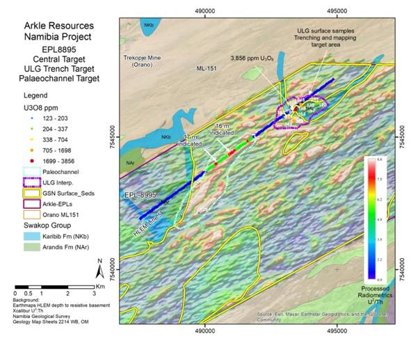
Published central HLEM line and ULG outline in their own source frame; May interpretation cannot be registered to September collars from visual similarity.

  • Central HLEM profile — Published resistive-basement profile line; 16–17 m annotations are interpretation, not verified mineralised thickness.
  • May ULG interpretation — May target outline; different vintage toSeptember footprint. No volume inferred.

EPL 8290 · May geophysical original

Native licence outline digitised for dated context only. Response raster is retained in Original/Compare; numerical geophysics cannot be recovered from its colour image.

  • EPL 8290 historical drawn outline — Approximate map outline, not a current cadastral boundary.

EPL 8298 · environmental target waypoints

Reported latitude/longitude preserved. Relative metric layout about centroid only; datum unspecified. These are target waypoints, not assays or collars.

  • 1-A — Historical exploration target waypoint, not assay or collar
  • 1-B — Historical exploration target waypoint, not assay or collar
  • 1-C — Historical exploration target waypoint, not assay or collar
  • 2-A — Historical exploration target waypoint, not assay or collar
  • 2-B — Historical exploration target waypoint, not assay or collar
  • 2-C — Historical exploration target waypoint, not assay or collar
  • 2-D — Historical exploration target waypoint, not assay or collar
  • 2-E — Historical exploration target waypoint, not assay or collar
  • 2-F — Historical exploration target waypoint, not assay or collar
  • 2-G — Historical exploration target waypoint, not assay or collar
  • 2-H — Historical exploration target waypoint, not assay or collar
  • 2-I — Historical exploration target waypoint, not assay or collar
  • 2-unlabelled-row — Historical exploration target waypoint, not assay or collar
  • 3-A — Historical exploration target waypoint, not assay or collar
  • 3-B — Historical exploration target waypoint, not assay or collar
  • 3-C — Historical exploration target waypoint, not assay or collar
  • 3-D — Historical exploration target waypoint, not assay or collar
  • 3-E — Historical exploration target waypoint, not assay or collar

EPL 7986 · environmental target waypoints

Reported latitude/longitude preserved. Relative metric layout about centroid only; datum unspecified. These are target waypoints, not assays or collars.

  • A — Historical exploration target waypoint, not assay or collar
  • B — Historical exploration target waypoint, not assay or collar
  • C — Historical exploration target waypoint, not assay or collar
  • D — Historical exploration target waypoint, not assay or collar
  • E — Historical exploration target waypoint, not assay or collar
  • F — Historical exploration target waypoint, not assay or collar
  • G — Historical exploration target waypoint, not assay or collar
  • H — Historical exploration target waypoint, not assay or collar
  • I — Historical exploration target waypoint, not assay or collar

EPL 8995 · 2026 drill fences

September 2026 programme map. Select recoverable collar-symbol fragments in the eastern and western fences; mapped symbols are not a verified hole census. The inset is excluded from digitisation. Individual depths, directions and assays remain unavailable.

  • ULG — 9 holes / 1, 154 m. Leucogranite host rock observed at depth; drill assays pending.
  • Paleo East — 66 holes / 1, 390 m. Palaeochannel target; drilling assays pending.
  • Paleo West — 12 holes / 168 m. Separate western palaeochannel; drilling assays pending.
  • 2026 collar mark 1 — Anonymous source-symbol fragment. Closely spaced symbols can merge in this low-resolution map; not a surveyed collar or assay. No hole ID assigned.
  • 2026 collar mark 4 — Anonymous source-symbol fragment. Closely spaced symbols can merge in this low-resolution map; not a surveyed collar or assay. No hole ID assigned.
  • 2026 collar mark 5 — Anonymous source-symbol fragment. Closely spaced symbols can merge in this low-resolution map; not a surveyed collar or assay. No hole ID assigned.
  • 2026 collar mark 6 — Anonymous source-symbol fragment. Closely spaced symbols can merge in this low-resolution map; not a surveyed collar or assay. No hole ID assigned.
  • 2026 collar mark 9 — Anonymous source-symbol fragment. Closely spaced symbols can merge in this low-resolution map; not a surveyed collar or assay. No hole ID assigned.
  • 2026 collar mark 11 — Anonymous source-symbol fragment. Closely spaced symbols can merge in this low-resolution map; not a surveyed collar or assay. No hole ID assigned.
  • 2026 collar mark 12 — Anonymous source-symbol fragment. Closely spaced symbols can merge in this low-resolution map; not a surveyed collar or assay. No hole ID assigned.
  • 2026 collar mark 14 — Anonymous source-symbol fragment. Closely spaced symbols can merge in this low-resolution map; not a surveyed collar or assay. No hole ID assigned.
  • 2026 collar mark 18 — Anonymous source-symbol fragment. Closely spaced symbols can merge in this low-resolution map; not a surveyed collar or assay. No hole ID assigned.
  • 2026 collar mark 19 — Anonymous source-symbol fragment. Closely spaced symbols can merge in this low-resolution map; not a surveyed collar or assay. No hole ID assigned.
  • 2026 collar mark 20 — Anonymous source-symbol fragment. Closely spaced symbols can merge in this low-resolution map; not a surveyed collar or assay. No hole ID assigned.

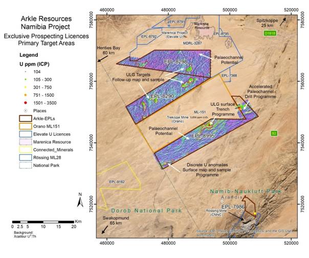
Four licences • issuer regional context

April 2026 issuer regional map, source-local only. Nearby deposits are contextual and do not demonstrate an Arkle resource.

    Erongo · terrain & satellite context

    Regional geographic context covering the four-licence area. True elevation scale ×1; exploration drawings remain source-local. Satellite mosaic is dated per contributing scene.

      Paleo East · historical collars & intervals

      June 2026 gamma survey. Historical collar marks, interpreted channel banks and HLEM traverses. Callout oxide labels omit e; prose identifies gamma-derived equivalent uranium. Geological depth interpretation is not mineralised thickness.

      • VB05 / VB06 pair — identity association unresolved — Source ring position only. VB05 and VB06 labels overlap; individual ring-to-ID linkage cannot be confidently resolved.
      • VB05 / VB06 pair — identity association unresolved — Source ring position only. VB05 and VB06 labels overlap; individual ring-to-ID linkage cannot be confidently resolved.
      • RC08 · historical collar symbol — Ring linked to the RC08 interval callout. No total depth, collar elevation or orientation disclosed.
      • Probed historical mark 1 — Visible green historical-probe mark; anonymous display ID. No result inferred for this mark.
      • Probed historical mark 2 — Visible green historical-probe mark; anonymous display ID. No result inferred for this mark.
      • Probed historical mark 3 — Visible green historical-probe mark; anonymous display ID. No result inferred for this mark.
      • Probed historical mark 5 — Visible green historical-probe mark; anonymous display ID. No result inferred for this mark.
      • Probed historical mark 6 — Visible green historical-probe mark; anonymous display ID. No result inferred for this mark.
      • Probed historical mark 9 — Visible green historical-probe mark; anonymous display ID. No result inferred for this mark.
      • Probed historical mark 12 — Visible green historical-probe mark; anonymous display ID. No result inferred for this mark.
      • HLEM traverse 1 — Plan-view traverse; colour profile remains in original. Inversion and calibrated depth grid unavailable.
      • HLEM traverse 2 — Plan-view traverse; colour profile remains in original. Inversion and calibrated depth grid unavailable.
      • Published channel / sediment boundary 1 — Partial source-drawn boundary; colour and frame retained. Not a surveyed bank or 3D channel floor.
      • Published channel / sediment boundary 2 — Partial source-drawn boundary; colour and frame retained. Not a surveyed bank or 3D channel floor.
      • Published channel / sediment boundary 3 — Partial source-drawn boundary; colour and frame retained. Not a surveyed bank or 3D channel floor.
      • HLEM depth annotation 12.5 m — Figure annotation is interpreted basement depth. Caption mentions a 12.5 m potential maximum while figure also labels 16 m; retain both without reconciliation.
      • HLEM depth annotation 16 m — Figure annotation is interpreted basement depth. Caption mentions a 12.5 m potential maximum while figure also labels 16 m; retain both without reconciliation.

      Northern licences · regional radiometrics

      Government radiometric backdrop in U counts per second (cps), not uranium assay grade. Native licence and target outlines are selected source features; quantitative grid values cannot be recovered from the colour picture.

      • Published EPL 8298 — Page20 approximate outline. Pixel correspondence checked visually against page20; not georegistration.
      • Published EPL 8290 — Page20 approximate outline. Pixel correspondence checked visually against page20; not georegistration.
      • Published EPL 8995 — Page20 approximate outline. Pixel correspondence checked visually against page20; not georegistration.

      Paleo East · sample classes & channel banks

      2025 selective surface samples, reported in ppm U₃O₈. Native banks and sample classes are source-local. Base imagery acquisition is not disclosed by the presentation.

      • Published palaeochannel bank 1 — Digitised source red bank interpretation; no independently surveyed position or channel depth.
      • Published palaeochannel bank 2 — Digitised source red bank interpretation; no independently surveyed position or channel depth.
      • 773 ppm U₃O₈ — Selected 2025 surface sample; exact sample ID and support not provided by this figure.
      • 2782 ppm U₃O₈ — Selected 2025 surface sample; exact sample ID and support not provided by this figure.
      • 1698 ppm U₃O₈ — Selected 2025 surface sample; exact sample ID and support not provided by this figure.
      • 250–500 ppm surface class — Manually digitised clear coloured sample symbol. Source bin label copied verbatim; boundary inclusivity not stated. No exact grade inferred.
      • 250–500 ppm surface class — Manually digitised clear coloured sample symbol. Source bin label copied verbatim; boundary inclusivity not stated. No exact grade inferred.
      • 250–500 ppm surface class — Manually digitised clear coloured sample symbol. Source bin label copied verbatim; boundary inclusivity not stated. No exact grade inferred.
      • 100–250 ppm surface class — Manually digitised clear coloured sample symbol. Source bin label copied verbatim; boundary inclusivity not stated. No exact grade inferred.
      • 100–250 ppm surface class — Manually digitised clear coloured sample symbol. Source bin label copied verbatim; boundary inclusivity not stated. No exact grade inferred.
      • 100–250 ppm surface class — Manually digitised clear coloured sample symbol. Source bin label copied verbatim; boundary inclusivity not stated. No exact grade inferred.
      • 100–250 ppm surface class — Manually digitised clear coloured sample symbol. Source bin label copied verbatim; boundary inclusivity not stated. No exact grade inferred.
      • 100–250 ppm surface class — Manually digitised clear coloured sample symbol. Source bin label copied verbatim; boundary inclusivity not stated. No exact grade inferred.
      • 100–250 ppm surface class — Manually digitised clear coloured sample symbol. Source bin label copied verbatim; boundary inclusivity not stated. No exact grade inferred.
      • 100–250 ppm surface class — Manually digitised clear coloured sample symbol. Source bin label copied verbatim; boundary inclusivity not stated. No exact grade inferred.
      • 100–250 ppm surface class — Manually digitised clear coloured sample symbol. Source bin label copied verbatim; boundary inclusivity not stated. No exact grade inferred.
      • 100–250 ppm surface class — Manually digitised clear coloured sample symbol. Source bin label copied verbatim; boundary inclusivity not stated. No exact grade inferred.
      • 100–250 ppm surface class — Manually digitised clear coloured sample symbol. Source bin label copied verbatim; boundary inclusivity not stated. No exact grade inferred.

      Paleo East · mapped geology

      Native flat geological colour fragments from the published map. Gaps preserve labels, contacts and uncertain pixels. Regional formation assignments are source interpretations, not underground surfaces.

      • Karibib Formation · visible fragment — Conservative source-colour fragment, clipped to visible project area. Pixel-classification reconstruction, not new geological interpretation. Unknown and covered pixels excluded.
      • Karibib Formation · visible fragment — Conservative source-colour fragment, clipped to visible project area. Pixel-classification reconstruction, not new geological interpretation. Unknown and covered pixels excluded.
      • Chuos Formation · visible fragment — Conservative source-colour fragment, clipped to visible project area. Pixel-classification reconstruction, not new geological interpretation. Unknown and covered pixels excluded.
      • Chuos Formation · visible fragment — Conservative source-colour fragment, clipped to visible project area. Pixel-classification reconstruction, not new geological interpretation. Unknown and covered pixels excluded.
      • Arandis Formation · visible fragment — Conservative source-colour fragment, clipped to visible project area. Pixel-classification reconstruction, not new geological interpretation. Unknown and covered pixels excluded.
      • Arandis Formation · visible fragment — Conservative source-colour fragment, clipped to visible project area. Pixel-classification reconstruction, not new geological interpretation. Unknown and covered pixels excluded.
      • Arandis Formation · visible fragment — Conservative source-colour fragment, clipped to visible project area. Pixel-classification reconstruction, not new geological interpretation. Unknown and covered pixels excluded.
      • Red Granite C · visible fragment — Conservative source-colour fragment, clipped to visible project area. Pixel-classification reconstruction, not new geological interpretation. Unknown and covered pixels excluded.
      • Published EPL8995 boundary — Source-local tracing from the page22 geological map; no surveyed coordinates or three-dimensional interpretation.
      • Mapped 2025 sample mark 1 — Source-local tracing from the page22 geological map; no surveyed coordinates or three-dimensional interpretation.
      • Mapped 2025 sample mark 2 — Source-local tracing from the page22 geological map; no surveyed coordinates or three-dimensional interpretation.
      • Mapped 2025 sample mark 3 — Source-local tracing from the page22 geological map; no surveyed coordinates or three-dimensional interpretation.
      • Mapped 2025 sample mark 4 — Source-local tracing from the page22 geological map; no surveyed coordinates or three-dimensional interpretation.
      • Mapped 2025 sample mark 5 — Source-local tracing from the page22 geological map; no surveyed coordinates or three-dimensional interpretation.
      • Mapped 2025 sample mark 6 — Source-local tracing from the page22 geological map; no surveyed coordinates or three-dimensional interpretation.
      • Mapped 2025 sample mark 7 — Source-local tracing from the page22 geological map; no surveyed coordinates or three-dimensional interpretation.
      • Mapped 2025 sample mark 8 — Source-local tracing from the page22 geological map; no surveyed coordinates or three-dimensional interpretation.
      • Mapped 2025 sample mark 9 — Source-local tracing from the page22 geological map; no surveyed coordinates or three-dimensional interpretation.
      • Mapped 2025 sample mark 10 — Source-local tracing from the page22 geological map; no surveyed coordinates or three-dimensional interpretation.
      • Mapped 2025 sample mark 11 — Source-local tracing from the page22 geological map; no surveyed coordinates or three-dimensional interpretation.
      • Mapped 2025 sample mark 12 — Source-local tracing from the page22 geological map; no surveyed coordinates or three-dimensional interpretation.
      • Mapped 2025 sample mark 13 — Source-local tracing from the page22 geological map; no surveyed coordinates or three-dimensional interpretation.
      • Mapped 2025 sample mark 14 — Source-local tracing from the page22 geological map; no surveyed coordinates or three-dimensional interpretation.
      • Mapped 2025 sample mark 15 — Source-local tracing from the page22 geological map; no surveyed coordinates or three-dimensional interpretation.
      • Mapped 2025 sample mark 16 — Source-local tracing from the page22 geological map; no surveyed coordinates or three-dimensional interpretation.
      • Mapped 2025 sample mark 17 — Source-local tracing from the page22 geological map; no surveyed coordinates or three-dimensional interpretation.
      • Mapped bank 1 — Source-local tracing from the page22 geological map; no surveyed coordinates or three-dimensional interpretation.
      • Mapped bank 2 — Source-local tracing from the page22 geological map; no surveyed coordinates or three-dimensional interpretation.

      North Rössing · labelled surface samples

      Six labelled surface results. The figure prints 2,924 ppm whereas acquisition prose gives 2,923 ppm; both retained as an unresolved source discrepancy, not averaged.

      • 704 ppm U₃O₈ — Published sample callout; crowded leader associations approximate. Source sample ID absent.
      • 848 ppm U₃O₈ — Published sample callout; crowded leader associations approximate. Source sample ID absent.
      • 2,924 ppm U₃O₈ — Published sample callout; crowded leader associations approximate. Source sample ID absent. Figure2924 vs prose2923 discrepancy unresolved.
      • 450 ppm U₃O₈ — Published sample callout; crowded leader associations approximate. Source sample ID absent.
      • 393 ppm U₃O₈ — Published sample callout; crowded leader associations approximate. Source sample ID absent.
      • 979 ppm U₃O₈ — Published sample callout; crowded leader associations approximate. Source sample ID absent.

      EPL 8995 · terrain & satellite

      True elevation scale ×1. Camera focus is regional context near the licence, not a surveyed project boundary. No source-local exploration overlay has been placed on the terrain.

        EPL 8290 · terrain & satellite

        True elevation scale ×1. Camera focus is regional context near the licence, not a surveyed project boundary. No source-local exploration overlay has been placed on the terrain.

          EPL 8298 · terrain & satellite

          True elevation scale ×1. Camera focus is regional context near the licence, not a surveyed project boundary. No source-local exploration overlay has been placed on the terrain.

            EPL 7986 · terrain & satellite

            True elevation scale ×1. Camera focus is regional context near the licence, not a surveyed project boundary. No source-local exploration overlay has been placed on the terrain.

              04 / DISCLOSURE CHRONOLOGY

              What happened, and what remains expected.

              Detailed disclosure chronology

              Follow-on ULG drilling preparation

              Q4 programme being planned; budget, collar plan and actual mobilisation require confirmation.

              planned

              Reported 14 September 2026 · Disclosure date; underlying observation date not separately disclosed

              Source ↗
              Sources & basis
              Extensive Uranium System Defined at ULG Target — ULG drilling and next steps

              Expected drilling assay disclosure

              16 September interim says within20days, spanning earlyOctober; not yet recovered at cutoff. Original14September guidance was duringSeptember.

              planned

              Reported 16 September 2026 · Disclosure date; underlying observation date not separately disclosed

              Reported 14 September 2026 · Disclosure date; underlying observation date not separately disclosed

              Source ↗Source ↗
              Sources & basis
              Interim Results · Extensive Uranium System Defined at ULG Target — CEO interim statement; technical next steps

              Interim results and cash update

              €650k approximate current cash; assay timetable remains expected.

              reported

              Reported 16 September 2026 · Disclosure date; underlying observation date not separately disclosed

              Source ↗
              Sources & basis
              Interim Results — Dated announcement: Interim results and cash update

              Trench assays and completed drilling

              87 holes / 2,712 m; drill assays pending.

              reported

              Reported 14 September 2026 · Disclosure date; underlying observation date not separately disclosed

              Source ↗
              Sources & basis
              Extensive Uranium System Defined at ULG Target — Dated announcement: Trench assays and completed drilling

              Warrant exercise and TVR

              £105k; dilution recorded separately.

              reported

              Reported 9 September 2026 · Disclosure date; underlying observation date not separately disclosed

              Source ↗
              Sources & basis
              Exercise of Warrants — Dated announcement: Warrant exercise and TVR

              Namibia acquisition and placing

              85% interest, four EPLs; purchase and exploration budget distinct.

              reported

              Reported 29 January 2026 · Disclosure date; underlying observation date not separately disclosed

              Source ↗
              Sources & basis
              Acquisition of Namibia Uranium and £1.7m Placing — Dated announcement: Namibia acquisition and placing
              05 / CORPORATE CONTEXT

              Funding and people.

              Funding snapshots

              Cash at period end

              €1.069m

              As at 30 June 2026 · €1.069m period-end balance

              Unaudited group cash; not a current treasury balance.

              Source ↗
              Sources & basis

              Later cash statement

              ~€650k

              Reported 16 September 2026 · Approximately €650k described as current cash; exact treasury measurement date not separately disclosed

              Issuer said the current planned programmes were funded. Expanded programmes require their own budget.

              Source ↗
              Sources & basis

              Placing proceeds

              £1.7m gross

              Reported 29 January 2026 · Acquisition and contractual terms announced; payment deadlines are contractual, not proof of current unpaid balances

              Separate from acquisition consideration; gross fundraising is not cash remaining.

              Source ↗
              Sources & basis

              Acquisition cash still scheduled

              £437k

              Reported 29 January 2026 · Acquisition and contractual terms announced; payment deadlines are contractual, not proof of current unpaid balances

              £242k Dec 2026 · £195k Dec 2027

              Subject to the disclosed acceleration terms. Total purchase consideration was £2.032m, including shares.

              Source ↗
              Sources & basis

              Cash used in H1

              €1.590m investing

              Period ended 30 June 2026 · Six months ended; all cash-flow and loss figures in this claim

              Operating outflow €147k; financing inflow €2.498m. Operating spend alone understates cash consumption.

              Source ↗
              Sources & basis

              Warrant exercise

              35.0m shares

              Reported 9 September 2026 · 35,000,009 warrant shares and £105k proceeds; admission expected around 14 September, not confirmed by this notice

              September 2026 · £105k proceeds

              Expected post-admission capital: 1,630,311,006 shares. Options and warrants need a reconciled register.

              Source ↗
              Sources & basis
              Funding, obligations and dilution: full evidence and reconciliations

              Acquisition cost is not the placing

              Reported 29 January 2026 · Acquisition and contractual terms announced; payment deadlines are contractual, not proof of current unpaid balances

              Purchase consideration was £2.032m: 305m shares at 0.4p (£1.220m) plus £812k cash. Cash terms were £375k initial, £242k due by 31 December 2026 and £195k by 31 December 2027. The £1.7m gross placing was a separate funding transaction.

              Source ↗
              Sources & basis
              Acquisition of Namibia Uranium and £1.7m Placing — Fundraise and Use of Proceeds; Consideration

              Resource trigger is only a contract term

              Reported 29 January 2026 · Acquisition and contractual terms announced; payment deadlines are contractual, not proof of current unpaid balances

              £390k of deferred cash accelerates if an inferred resource of at least 20 Mlb U₃O₈ at minimum 120 ppm is published under JORC or NI 43-101. This is not a Mineral Resource, an Exploration Target or a management estimate of likely inventory.

              Source ↗
              Sources & basis

              Two different cash dates

              As at 30 June 2026 · €1.069m period-end balance

              Reported 16 September 2026 · Approximately €650k described as current cash; exact treasury measurement date not separately disclosed

              June 2026 period-end cash was €1.069m. The 16 September interim also reported current cash of about €650k and said current planned programmes were funded. Neither number is a verified 30 September treasury balance or funding for an enlarged programme.

              Source ↗
              Sources & basis
              Interim Results — Corporate highlights; consolidated statement of financial position

              Exploration spend matters

              Period ended 30 June 2026 · Six months ended; all cash-flow and loss figures in this claim

              In the first half of 2026, operating cash use was €147k, investing outflow €1.590m and financing inflow €2.498m. The €947k loss includes a €455k non-cash option charge. Operating outflow alone understates total cash consumption.

              Source ↗
              Sources & basis
              Interim Results — Cash-flow statement and corporate highlights

              Funding remains a workstream

              As at 31 December 2025 · Irish licence commitments €54,875 over two years

              Period ended 31 December 2025 · Annual audited accounts and going-concern assessment

              Reported 16 September 2026 · Later statement on funding the currently planned programmes

              The 2025 audit contains an unmodified opinion with a material uncertainty related to going concern, dependent on additional finance. Annual note23 records €54,875 Irish licence commitments over two years and potential dilution if Stonepark cash calls are not met. The interim’s current programme funding statement has a narrower scope.

              Source · p. 25 ↗Source ↗
              Sources & basis
              Annual report 2025 · Interim Results — Annual PDF pp25–26 and55; interim corporate / Stonepark discussion

              Dilution and equity compensation

              Reported 9 September 2026 · 35,000,009 warrant shares and £105k proceeds; admission expected around 14 September, not confirmed by this notice

              As at 1 April 2026 · Option transaction date in the PDMR appendix

              Reported 2 April 2026 · 130m options announced; interim narrative instead says granted on 2 April

              September warrant exercise added 35,000,009 shares at 0.3p for £105k, with expected post-admission capital of 1,630,311,006. April’s 130m options at 0.95p replace earlier management/director options; they are not issued shares. A current full warrant schedule remains required.

              Source ↗Source ↗
              Sources & basis

              Ireland and Botswana only as corporate context

              Period ended 31 December 2025 · Annual commitments and cash-call terms

              Reported 16 September 2026 · Stonepark programme funding and Botswana plans

              The interim describes partner-funded Stonepark drilling at no cash cost to Arkle for that programme. This should be read alongside dilution/cash-call terms. Botswana first drilling depends on completion of its environmental assessment and corporate priorities; neither asset is included in the uranium scene.

              Source ↗Source ↗
              Sources & basis
              Interim Results · Annual report 2025 — Interim CEO comment and annual note23

              Cash and liabilities need dated definitions

              As at 30 June 2026 · All balance-sheet, payables and accrued remuneration figures

              Reported 16 September 2026 · Separate approximately €650k current-cash statement; exact measurement date not disclosed

              At 30 June 2026, the interim reports net current liabilities of about €62 k, including €886 k trade/other payables and a €266 k warrant accounting liability. Payables include €507 k deferred consideration and €203, 141 accrued director remuneration. The warrant liability is not simply a cash loan. Neither period-end balances nor the 16 September ~€650 k cash statement establish September 30 runway.

              Source ↗
              Sources & basis
              Interim Results — Statement of financial position; note 8 Trade and other payables

              Option note needs correction by the issuer

              Period ended 30 June 2026 · Interim option roll-forward and valuation table

              Reported 2 April 2026 · Option terms; appendix transaction date 1 April 2026

              The interim option roll-forward shows opening 13.6 m, granted 130 m and cancelled 13.6 m, but a closing row 16.1 m; narrative and exercisable row state 130 m. The valuation table also appears to interchange the 0.575 p share price and 0.95 p exercise price relative to the April announcement. Do not calculate fully diluted capital from this inconsistent table; obtain the current option/warrant register.

              Source ↗Source ↗
              Sources & basis
              Interim Results · Warrant Exercise, Director Shareholdings & Options — Interim share-based payments note; April option terms

              Programme funding is narrower than expansion funding

              Reported 29 January 2026 · Placing, adviser and acquisition shares; contractual cash due 31 December 2026 and 31 December 2027

              Reported 9 September 2026 · Warrant exercise proceeds and expected admission

              Reported 16 September 2026 · Later funding statement; not a current unpaid-obligations confirmation

              The January 425 m placing shares raised £1.7 m gross, with 7.5 m adviser shares and 305 m acquisition shares separately issued. September’s 35, 000, 009 warrant shares add £105 k at 0.3 p, not a new placement. Outstanding acquisition cash is £242 k due December 2026 and £195 k December 2027, subject to acceleration terms. A costed next programme, currency-specific obligations and cash-date bridge are needed before a runway estimate.

              Source ↗Source ↗Source ↗
              Sources & basis
              Acquisition of Namibia Uranium and £1.7m Placing · Exercise of Warrants · Interim Results — Fundraise, consideration and share capital disclosures

              Share admission notices also need reconciliation

              Reported 27 February 2026 · Expected post-admission capital

              Reported 13 March 2026 · Later expected post-admission capital; arithmetic discrepancy retained

              Period ended 30 June 2026 · H1 warrant issues/proceeds and June closing capital

              The 27 February notice states post-admission capital of 1,478,977,664. Adding the 14,333,333 shares announced on 13 March would produce 1,493,310,997, while that notice states 1,483,310,997. Retain the discrepancy rather than repairing a historical cap table. The interim separately reports 126,333,333 warrant shares and £433,000 proceeds in H1; its June closing capital is 1,595,310,997.

              Source ↗Source ↗Source ↗
              Sources & basis
              Warrants Exercise & Website Launch · Exercise of Warrants · Interim Results — Formal warrant/admission bodies; interim financial position and share capital

              People behind the programme

              Rory Harding

              Chief Executive Officer

              Company strategy and programme priorities.

              Source ↗
              Sources & basis

              Reported 16 September 2026 · Role identified in this disclosure

              John Teeling

              Chairman

              Board and corporate oversight.

              Source ↗
              Sources & basis

              Reported 16 September 2026 · Role identified in this disclosure

              Technical contributors

              Geophysics and geological interpretation

              Arrow Geosciences: airborne processing. Theo Aravanis: geophysics interpretation. Paul Nex and Judith Kinnaird: geological input.

              Source ↗
              Sources & basis

              Reported 22 May 2026 · Role identified in this disclosure

              Disclosed roles and review responsibilities

              Suggested review counterparts

              Reported 29 January 2026 · Namibia counterpart and acquisition roles

              Reported 14 September 2026 · Technical sign-off

              Reported 16 September 2026 · CEO and chairman roles

              Rory Harding (CEO) and John Teeling (Chairman) are the commercial entry points; the Namibia team and country lead Aron Haludilu should own database transfer. Dr Guy Freemantle of The MSA Group approved September technical content; ask the company to nominate its technical sign-off owner.

              Source ↗Source ↗Source ↗
              Sources & basis
              Interim Results · Acquisition of Namibia Uranium and £1.7m Placing · Extensive Uranium System Defined at ULG Target — Enquiries; acquisition consideration and team; Qualified Person statement

              Technical review has named counterparts

              Reported 22 May 2026 · Named technical contributors and roles

              Reported 14 September 2026 · September technical sign-off

              May identifies Willem Kotzé as Namibia Exploration Manager; Arrow Geosciences processed airborne data, Theo Aravanis interpreted geophysics, and Paul Nex/Judith Kinnaird supplied geological input. Guy Freemantle of MSA signs the technical content. These disclosed roles identify potential review owners; no unsupported management-quality score is assigned.

              Source ↗Source ↗
              Sources & basis
              06 / DATED MARKET CONTEXT

              Price & key developments

              0.725p · 29 September 2026 close

              Unadjusted daily close; local-currency price return; indexed first common session=100. Not total return, FX-adjusted return or causal attribution. GLD is a US gold ETF; URA is a US uranium/nuclear-equity ETF, not spot uranium. Both are broad context, not matched peers.

              Select a disclosure to see its evidenceQuality not assessed · dated research snapshot

              Company disclosures 7 events

              Source ↗Source ↗

              Sources & basis
              ARK.L daily market data · URA daily market data — Daily timestamp and closing-price series; first common session = 100

              Announcement-window returns and methods

              Return = (closing price ÷ previous-session close − 1) × 100. Later return uses five subsequent available sessions, or fewer where the series ends. Thin trading, spreads, other news and financing can affect these observations; this is not an impact attribution model.

              DisclosurePrior → event close (p)DayLater windowSources
              2026-09-16
              Interim results and cash update
              0.675 → 0.675+0.0%+7.4%
              5 later sessions to 2026-09-23
              Source ↗Source ↗
              Sources & basis
              2026-09-14
              Trench assays and completed drilling
              0.65 → 0.675+3.8%+23.1%
              5 later sessions to 2026-09-21
              Source ↗Source ↗
              Sources & basis
              2026-09-09
              Warrant exercise and TVR
              0.7 → 0.65-7.1%-3.6%
              5 later sessions to 2026-09-16
              Source ↗Source ↗
              Sources & basis
              2026-07-17
              Drilling underway
              0.75 → 0.75+0.0%+0.0%
              5 later sessions to 2026-07-24
              Source ↗Source ↗
              Sources & basis
              2026-06-25
              Mapping and trenching update
              0.65 → 0.7+7.7%+3.8%
              5 later sessions to 2026-07-02
              Source ↗Source ↗
              Sources & basis
              2026-05-22
              Targets defined; drilling accelerated
              0.65 → 0.7+7.7%+15.4%
              5 later sessions to 2026-06-01
              Source ↗Source ↗
              Sources & basis
              2026-01-29
              Namibia acquisition and placing
              0.525 → 0.445-15.2%-15.2%
              5 later sessions to 2026-02-05
              Source ↗Source ↗
              Sources & basis
              07 / RESEARCH LIBRARY

              Discoveries are counted separately from review.

              Repository guidance → Arkle questions → primary evidence → findings and visual implications. Draft-derived questions are explicitly labelled; active packs govern extraction.

              93Discovered records
              84Captured
              41Selected-section review
              3Full-document review

              Selected-source audit only: 2 partial captures, 7 inaccessible records, 2 registered duplicates and 47 unread records. Figure review does not count as full-document review.

              Open searchable source and document-review register
              DocumentAccess / reviewReview scope / limitationLocal capture
              Regulatory archive
              archive · Publication date unconfirmedSource ↗
              captured
              selected sections
              Dated headline discovery and cutoff check; linked articles reviewed only where individually registered.Captured original
              Extracted text
              Issuer home
              issuer-home · Publication date unconfirmedSource ↗
              partially captured
              unread
              Captured/indexed only; not read for substantive claims.Captured original
              Extracted text
              Issuer sitemap
              issuer-sitemap · Publication date unconfirmedSource ↗
              captured
              unread
              Excluded from uranium technical inference; headline triage only. Retained for future governance/capital chronology; no full review claimed.Captured original
              Extracted text
              Annual report 2024
              annual-2024 · 2025-06Source ↗
              inaccessible
              unread
              404 Client Error: Not Found for url: https://arkleresources.com/wp-content/uploads/2025/06/Arkle-Annual-Report-2024-1.pdfNot recovered
              Namibia Geological and Mineral Information System
              namibia-gmis · Publication date unconfirmedSource ↗
              inaccessible
              unread
              HTTPSConnectionPool(host='www.mme.gov.na', port=443): Max retries exceeded with url: /edn/ (Caused by NameResolutionError("<urllib3.connection.HTTPSConnection object at 0x103313b90>: Failed to resolve 'www.mme.gov.na' ([Errno 8] nodename nor servname provided, or not known)"))Not recovered
              Interim Results
              rns-9773898 · 2026-09-16Source ↗
              captured
              full
              Full formal issuer interim body including financial statements and notes (third-party AI preamble excluded)Captured original
              Extracted text
              Extensive Uranium System Defined at ULG Target
              rns-9769143 · 2026-09-14Source ↗
              captured
              full
              Entire issuer announcement text, tables, glossary/qualified-person statement and Figures1–2; host navigation and host-generated AI summary excluded from issuer evidenceCaptured original
              Extracted text
              Exercise of Warrants
              rns-9761835 · 2026-09-09Source ↗
              captured
              selected sections
              September TVR; April options termsCaptured original
              Extracted text
              Admission to OTCID Basic Market in United States
              rns-9697123 · 2026-07-31Source ↗
              captured
              unread
              Excluded from uranium technical inference; headline triage only. Retained for future governance/capital chronology; no full review claimed.Captured original
              Extracted text
              Result of AGM
              rns-9684851 · 2026-07-23Source ↗
              captured
              full
              Full formal issuer AGM announcement including substantive uranium and corporate update (third-party AI preamble excluded)Captured original
              Extracted text
              Stonepark Zinc Update: New Zone Discovered
              rns-9683933 · 2026-07-23Source ↗
              captured
              unread
              Outside uranium technical scope; retained, unread unless marked otherwise. No transfer of resources or results to Namibia.Captured original
              Extracted text
              Namibia Uranium Drilling Underway
              rns-9673552 · 2026-07-17Source ↗
              captured
              selected sections
              Dated announcement: Drilling underwayCaptured original
              Extracted text
              Notice of Annual General Meeting
              rns-9659726 · 2026-07-09Source ↗
              captured
              unread
              Excluded from uranium technical inference; headline triage only. Retained for future governance/capital chronology; no full review claimed.Captured original
              Extracted text
              Holding(s) in Company
              rns-9657055 · 2026-07-07Source ↗
              captured
              unread
              Excluded from uranium technical inference; headline triage only. Retained for future governance/capital chronology; no full review claimed.Captured original
              Extracted text
              Rescheduling of Investor Webcast
              rns-9648459 · 2026-07-02Source ↗
              captured
              unread
              Excluded from uranium technical inference; headline triage only. Retained for future governance/capital chronology; no full review claimed.Captured original
              Extracted text
              Publication of Annual Report and Accounts
              rns-9641824 · 2026-06-29Source ↗
              captured
              unread
              Excluded from uranium technical inference; headline triage only. Retained for future governance/capital chronology; no full review claimed.Captured original
              Extracted text
              Notice of Investor Webcast
              rns-9640593 · 2026-06-29Source ↗
              captured
              unread
              Excluded from uranium technical inference; headline triage only. Retained for future governance/capital chronology; no full review claimed.Captured original
              Extracted text
              Namibia Uranium Exploration Update
              rns-9635389 · 2026-06-25Source ↗
              captured
              selected sections
              Formal programme, trench sampling, legacy relogging and technical sectionsCaptured original
              Extracted text
              Preliminary Results for Year Ended 31 Dec 2025
              rns-9630731 · 2026-06-23Source ↗
              captured
              selected sections
              Chairman and Namibia post-balance-sheet sections; not full financial reviewCaptured original
              Extracted text
              Exercise of Warrants and TVR
              rns-9607462 · 2026-06-08Source ↗
              captured
              selected sections
              Formal issuer warrant exercise / admission / director purchase body; enquiries and ancillary notification forms excludedCaptured original
              Extracted text
              Appointment of Joint Broker
              rns-9598431 · 2026-06-03Source ↗
              captured
              unread
              Excluded from uranium technical inference; headline triage only. Retained for future governance/capital chronology; no full review claimed.Captured original
              Extracted text
              Director Dealing
              rns-9583901 · 2026-05-26Source ↗
              captured
              selected sections
              Formal issuer warrant exercise / admission / director purchase body; enquiries and ancillary notification forms excludedCaptured original
              Extracted text
              Uranium Targets Defined; Drilling Accelerated
              rns-9581203 · 2026-05-22Source ↗
              captured
              selected sections
              Formal Phase1 results, next steps and technical team; all substantive sectionsCaptured original
              Extracted text
              Exercise of Warrants
              rns-9562906 · 2026-05-12Source ↗
              captured
              selected sections
              Formal issuer warrant exercise / admission / director purchase body; enquiries and ancillary notification forms excludedCaptured original
              Extracted text
              Director Dealing
              rns-9533759 · 2026-04-23Source ↗
              captured
              selected sections
              Formal issuer warrant exercise / admission / director purchase body; enquiries and ancillary notification forms excludedCaptured original
              Extracted text
              Appointment of Nominated & Financial Adviser
              rns-9526436 · 2026-04-17Source ↗
              captured
              unread
              Excluded from uranium technical inference; headline triage only. Retained for future governance/capital chronology; no full review claimed.Captured original
              Extracted text
              Stonepark Zinc Project – Operations Update
              rns-9524046 · 2026-04-16Source ↗
              captured
              unread
              Outside uranium technical scope; retained, unread unless marked otherwise. No transfer of resources or results to Namibia.Captured original
              Extracted text
              Stonepark Zinc Project – Operations Update
              rns-9524016 · 2026-04-16Source ↗
              captured
              unread
              Outside uranium technical scope; retained, unread unless marked otherwise. No transfer of resources or results to Namibia.Captured original
              Extracted text
              Warrant Exercise, Director Shareholdings & Options
              rns-9504442 · 2026-04-02Source ↗
              captured
              selected sections
              September TVR; April options termsCaptured original
              Extracted text
              Total Voting Rights
              rns-9504134 · 2026-04-01Source ↗
              captured
              unread
              Excluded from uranium technical inference; headline triage only. Retained for future governance/capital chronology; no full review claimed.Captured original
              Extracted text
              Uranium Updates - Geophysical Surveys Complete
              rns-9501735 · 2026-04-01Source ↗
              captured
              selected sections
              Formal uranium survey completion body, line spacing, line-km and historical holesCaptured original
              Extracted text
              Exercise of Warrants
              rns-9483051 · 2026-03-19Source ↗
              captured
              selected sections
              Formal issuer warrant exercise / admission / director purchase body; enquiries and ancillary notification forms excludedCaptured original
              Extracted text
              Exercise of Warrants
              rns-9474235 · 2026-03-13Source ↗
              captured
              selected sections
              Formal issuer warrant exercise / admission / director purchase body; enquiries and ancillary notification forms excludedCaptured original
              Extracted text
              Stonepark Zinc Project - Drilling Update
              rns-9473885 · 2026-03-13Source ↗
              captured
              unread
              Outside uranium technical scope; retained, unread unless marked otherwise. No transfer of resources or results to Namibia.Captured original
              Extracted text
              Total Voting Rights
              rns-9454331 · 2026-03-02Source ↗
              captured
              unread
              Excluded from uranium technical inference; headline triage only. Retained for future governance/capital chronology; no full review claimed.Captured original
              Extracted text
              Warrants Exercise & Website Launch
              rns-9449878 · 2026-02-27Source ↗
              captured
              selected sections
              Formal issuer warrant exercise / admission / director purchase body; enquiries and ancillary notification forms excludedCaptured original
              Extracted text
              Uranium Exploration Commenced in Namibia
              rns-9447653 · 2026-02-26Source ↗
              captured
              selected sections
              Formal uranium programme and geophysics bodyCaptured original
              Extracted text
              Company Updates
              rns-9441309 · 2026-02-23Source ↗
              captured
              selected sections
              Namibia strategy,178samples, planned vscompleted surveys; Botswana/Irish corporate context selected sectionsCaptured original
              Extracted text
              Acquisition of Namibia Uranium and £1.7m Placing
              rns-9392626 · 2026-01-29Source ↗
              captured
              selected sections
              Acquisition and consideration sections; About Namibia Uranium; 2025 sampling and laboratory method; Acquisition sampling table; presentation PDF pp21,23; Fundraise and Use of Proceeds; Consideration; Consideration footnote; Enquiries; acquisition consideration and team; Qualified Person statementCaptured original
              Extracted text
              Update on Stonepark
              rns-9241707 · 2025-11-18Source ↗
              captured
              unread
              Outside uranium technical scope; retained, unread unless marked otherwise. No transfer of resources or results to Namibia.Captured original
              Extracted text
              Holdings in Company
              rns-9226545 · 2025-11-11Source ↗
              captured
              unread
              Excluded from uranium technical inference; headline triage only. Retained for future governance/capital chronology; no full review claimed.Captured original
              Extracted text
              Interim Statement
              rns-9130082 · 2025-09-25Source ↗
              captured
              unread
              Captured/indexed only; not read for substantive claims.Captured original
              Extracted text
              Result of Annual General Meeting
              rns-9012969 · 2025-07-30Source ↗
              captured
              unread
              Captured/indexed only; not read for substantive claims.Captured original
              Extracted text
              Placing to raise £500,000
              rns-9011298 · 2025-07-30Source ↗
              captured
              unread
              Captured/indexed only; not read for substantive claims.Captured original
              Extracted text
              New Prospecting Licence Awarded in Botswana
              rns-8969827 · 2025-07-09Source ↗
              captured
              unread
              Outside uranium technical scope; retained, unread unless marked otherwise. No transfer of resources or results to Namibia.Captured original
              Extracted text
              Final Results for the Year Ended 31 December 2024
              rns-8946148 · 2025-06-25Source ↗
              captured
              unread
              Captured/indexed only; not read for substantive claims.Captured original
              Extracted text
              Update on Stonepark Zinc Project, Ireland
              rns-8931472 · 2025-06-16Source ↗
              captured
              unread
              Outside uranium technical scope; retained, unread unless marked otherwise. No transfer of resources or results to Namibia.Captured original
              Extracted text
              Lithium and Magnesium Identified in Botswana
              rns-8750467 · 2025-02-25Source ↗
              captured
              unread
              Outside uranium technical scope; retained, unread unless marked otherwise. No transfer of resources or results to Namibia.Captured original
              Extracted text
              Refocus of Activities on Stonepark Zinc Licence
              rns-8725558 · 2025-02-06Source ↗
              captured
              unread
              Outside uranium technical scope; retained, unread unless marked otherwise. No transfer of resources or results to Namibia.Captured original
              Extracted text
              Drilling Update on the Stonepark Zinc Project
              rns-8690169 · 2025-01-15Source ↗
              captured
              unread
              Outside uranium technical scope; retained, unread unless marked otherwise. No transfer of resources or results to Namibia.Captured original
              Extracted text
              Regulatory archive page 2
              archive-2 · Publication date unconfirmedSource ↗
              captured
              selected sections
              Dated headline discovery and cutoff check; linked articles reviewed only where individually registered.Captured original
              Extracted text
              Corporate presentation linked from uranium page
              presentation · 2026-04-02Source ↗
              captured
              selected sections
              PDF pp18–24: licence context, historical samples, exploration programme; key maps visually inspectedCaptured original
              Extracted text
              Annual report 2025
              annual-2025 · 2026-06-29Source ↗
              captured
              selected sections
              PDF pp25–26,55–56: auditor going concern, commitments, acquisition and optionsCaptured original
              Extracted text
              Annual report 2024 current website copy
              annual-2024-current · 2025-06Source ↗
              captured
              unread
              Captured/indexed only; not read for substantive claims.Captured original
              Extracted text
              Extensive Uranium System Defined at ULG Target – issuer feed
              issuer-ulg · 2026-09-14Source ↗
              captured
              duplicate
              Captured/indexed only; not read for substantive claims.Captured original
              Extracted text
              Interim Results – issuer feed
              issuer-interim · 2026-09-16Source ↗
              captured
              duplicate
              Captured/indexed only; not read for substantive claims.Captured original
              Extracted text
              Issuer regulatory feed
              issuer-feed · Publication date unconfirmedSource ↗
              partially captured
              unread
              Captured/indexed only; not read for substantive claims.Captured original
              Extracted text
              EPL8290 environmental management plan
              emp-8290 · Publication date unconfirmedSource ↗
              inaccessible
              unread
              HTTPSConnectionPool(host='eia.meft.gov.na', port=443): Max retries exceeded with url: /screening/5720_epl8290_updated_esmp_180622.pdf (Caused by ConnectTimeoutError(<urllib3.connection.HTTPSConnection object at 0x108b19410>, 'Connection to eia.meft.gov.na timed out. (connect timeout=35)'))Not recovered
              EPL7986 environmental management plan
              emp-7986 · Publication date unconfirmedSource ↗
              inaccessible
              unread
              HTTPSConnectionPool(host='eia.meft.gov.na', port=443): Max retries exceeded with url: /screening/5719_updated_emp_epl_7986.pdf (Caused by ConnectTimeoutError(<urllib3.connection.HTTPSConnection object at 0x108b1a4d0>, 'Connection to eia.meft.gov.na timed out. (connect timeout=35)'))Not recovered
              Namibia Uranium environmental application record
              eia-project · Publication date unconfirmedSource ↗
              inaccessible
              unread
              HTTPSConnectionPool(host='eia.meft.gov.na', port=443): Max retries exceeded with url: /web/projects/5739 (Caused by ConnectTimeoutError(<urllib3.connection.HTTPSConnection object at 0x108b19dd0>, 'Connection to eia.meft.gov.na timed out. (connect timeout=35)'))Not recovered
              EIS environmental report catalogue
              eis-index · Publication date unconfirmedSource ↗
              captured
              unread
              Captured/indexed only; not read for substantive claims.Captured original
              Extracted text
              5739_EMP_EPL 8298 Trekopje Erongo Region.pdf
              eis-8298-0 · 2025Source ↗
              captured
              selected sections
              PDF pp1–2,7–10: document scope, target waypoints, source-map inconsistenciesCaptured original
              Extracted text
              5739_Declaration of Authorship_EPL 8298 Trekopje Erongo Region.pdf
              eis-8298-1 · 2025Source ↗
              captured
              unread
              Excluded from uranium technical inference; headline triage only. Retained for future governance/capital chronology; no full review claimed.Captured original
              Extracted text
              5739_Environmental Audit_EPL 8298 Trekopje Erongo Region.pdf
              eis-8298-2 · 2025Source ↗
              captured
              unread
              Captured/indexed only; not read for substantive claims.Captured original
              Extracted text
              5739_ECC Old_EPL 8298 Trekopje Erongo Region.pdf
              eis-8298-3 · 2025Source ↗
              captured
              selected sections
              PDF p1 visually: former holder, issue and expiry dates; remaining scan not reviewedCaptured original
              Extracted text
              5739_Map_EPL 8298 Trekopje Erongo Region.pdf
              eis-8298-4 · 2025Source ↗
              captured
              selected sections
              PDF p1 target coordinates; compared with EMP Table 2Captured original
              Extracted text
              5739_Screening Notice_EPL 8298 Trekopje Erongo Region.pdf
              eis-8298-5 · 2025Source ↗
              captured
              unread
              Captured/indexed only; not read for substantive claims.Captured original
              Extracted text
              5739_CV_EPL 8298 Trekopje Erongo Region.pdf
              eis-8298-6 · 2025Source ↗
              captured
              unread
              Excluded from uranium technical inference; headline triage only. Retained for future governance/capital chronology; no full review claimed.Captured original
              Extracted text
              EPL7986 5719_EMP_EPL 7986 Arandis.pdf
              eis-7986-68 · 2025Source ↗
              captured
              selected sections
              PDF pp1,7–9: scope, target waypoints and renewal statusCaptured original
              Extracted text
              EPL7986 5719_Declaration of Authorship_EPL 7986 Arandis.pdf
              eis-7986-69 · 2025Source ↗
              captured
              unread
              Excluded from uranium technical inference; headline triage only. Retained for future governance/capital chronology; no full review claimed.Captured original
              Extracted text
              EPL7986 5719_ECC Old_EPL 7986 Arandis.pdf
              eis-7986-70 · 2025Source ↗
              captured
              selected sections
              PDF p1 visually: former holder, issue and expiry dates; remaining scan not reviewedCaptured original
              Extracted text
              EPL7986 5719_Map_EPL 7986 Arandis.pdf
              eis-7986-71 · 2025Source ↗
              captured
              unread
              Captured/indexed only; not read for substantive claims.Captured original
              Extracted text
              EPL7986 5719_Screening Notice_EPL 7986 Arandis.pdf
              eis-7986-72 · 2025Source ↗
              captured
              unread
              Captured/indexed only; not read for substantive claims.Captured original
              Extracted text
              EPL7986 5719_CV_EPL 7986 Arandis.pdf
              eis-7986-73 · 2025Source ↗
              captured
              unread
              Excluded from uranium technical inference; headline triage only. Retained for future governance/capital chronology; no full review claimed.Captured original
              Extracted text
              EPL8290 Environmental and Social Impact Assessment
              eis-8290-esia · 2022Source ↗
              captured
              selected sections
              PDF p1 and contents: draft 2022 ESIA identity; substantive impact chapters not reviewedCaptured original
              Extracted text
              ARK.L daily market data
              market-ARK.L · 2026-09-30Source ↗
              captured
              selected sections
              Currency, daily timestamps, closing prices, volume; invalid/null and cutoff-day bars excludedCaptured original
              URA daily market data
              market-URA · 2026-09-30Source ↗
              captured
              selected sections
              Currency, daily timestamps, closing prices, volume; invalid/null and cutoff-day bars excludedCaptured original
              2555_ESR_EPL 8995 in Erongo Region.pdf
              eis-8995-20 · 2023-12-18Source ↗
              captured
              selected sections
              PDF pp12,21,28,41,55: 8026→8995 history, rights access, legislation and heritage assessment wordingCaptured original
              Extracted text
              2555_ESMP_EPL 8995 in Erongo Region.pdf
              eis-8995-21 · 2023-12Source ↗
              captured
              selected sections
              PDF p9: history and environmental application purposeCaptured original
              Extracted text
              2555_ECC Old_EPL 8995 in Erongo Region.pdf
              eis-8995-22 · 2022-10-17Source ↗
              captured
              selected sections
              All one-page certificate visually reviewed; reverse-side conditions not suppliedCaptured original
              Extracted text
              2555_MME Grant_EPL 8995 in Erongo Region.pdf
              eis-8995-23 · 2023-08-01Source ↗
              captured
              selected sections
              All 8 scanned pages visually reviewed: preparedness notice, signed acceptance, conditions and duplicate coordinate appendicesCaptured original
              Extracted text
              2555_Proof of Consultation_EPL 8995 in Erongo Region.pdf
              eis-8995-24 · Publication date unconfirmedSource ↗
              captured
              unread
              Captured attachment; no substantive review claimed.Captured original
              Extracted text
              2555_Map_EPL 8995 in Erongo Region.pdf
              eis-8995-25 · 2023-12Source ↗
              captured
              selected sections
              One-page map visually reviewed: stated GCS WGS1984, centre, extent; not current legal controlCaptured original
              Extracted text
              2555_NHC Consent_EPL 8995 in Erongo Region.pdf
              eis-8995-26 · 2023-08-23Source ↗
              captured
              selected sections
              All 3 pages visually reviewed: consent names EPL8024/Parkland, not8995; validity ends22Aug2024Captured original
              Extracted text
              2555_Screening Notice_EPL 8995 in Erongo Region.pdf
              eis-8995-27 · 2024-01-19Source ↗
              captured
              selected sections
              Both pages reviewed: screening/application verification and further document requests, not final clearanceCaptured original
              Extracted text
              2555_CV_EPL 8995 in Erongo Region.pdf
              eis-8995-28 · Publication date unconfirmedSource ↗
              captured
              unread
              Excluded from uranium technical inference; headline triage only. Retained for future governance/capital chronology; no full review claimed.Captured original
              Extracted text
              2555_BID_EPL 8995 in Erongo Region.pdf
              eis-8995-29 · 2023Source ↗
              captured
              selected sections
              PDF p3 project history; rest not reviewedCaptured original
              Extracted text
              CIM Mineral Exploration Best Practice Guidelines 2018
              cim-exploration-2018 · 2018-11-23Source ↗
              captured
              selected sections
              Sampling, survey and QA/QC guidance selected sections; draft numerical bands not endorsedCaptured original
              Extracted text
              Copernicus GLO30 + Sentinel-2 geographic context
              copernicus-context · 2026-09-30Source ↗
              captured
              selected sections
              Provider CRS, raster footprint, elevation units and SCL local clear fraction; not geological interpretationCaptured original
              Four-licence geographic context: Copernicus GLO30 / Sentinel-2 mosaic
              copernicus-context-v3Source ↗
              captured
              selected_sections
              Provider CRS, coverage, EGM2008 units, acquisition dates and SCL clear-pixel mosaic; not surveyed exploration registrationContext provenance
              Earth Data Namibia public archive portal
              edn-portal-v3Source ↗
              inaccessible
              unread
              Indexed official description is a discovery lead; archive contents and Arkle coverage not verified.Access failed; see research audit
              GSN2023: A Geoscientific Data Base for Namibia
              edn-paper-v3Source ↗
              inaccessible
              unread
              Indexed official description is a discovery lead; archive contents and Arkle coverage not verified.Access failed; see research audit
              ULG geographic context and approximate map registration
              geographic-ulg-v4Source ↗
              captured
              selected_sections
              Local satellite/DSM, internal map-grid fit and approximate alignment limits; no survey validationRegistration review
              Version0003 research findings and limitations

              Arkle version 0003 — research and reconstruction findings

              Evidence cutoff: 30 September 2026. Public information only. This is an extension of the selected-source version 0002 audit, not a complete historical drilling or tenure audit.

              What the additional research recovered

              The original presentation contains embedded maps larger than the rendered page previews: pages 20 and21 are1733×975 pixels; the page 22 sampling map is652×734 and geology map556×626; the page 23 context map is1084×975. These source pixels are preserved under assets/v3. Their sample classes, bank interpretations, target boundaries, geological colours and labelled results support additional selectable geometry. The map backgrounds have no disclosed satellite acquisition date and are kept separate from the newly acquired dated geographic imagery. Issuer presentation

              The publisher's original June map is594×449 pixels, and September programme/ULG maps are477×418 and476×416. Fetching the original attachments did not reveal hidden high-resolution collar tables. Low-resolution marks can merge, so the reconstructed symbol fragments are not a count of unique holes or laboratory samples. The source imagery remains visible in Compare and available as a direct download.

              The June release supports five named historical intervals: VB05,2.7 m at99.5 ppm from0.4 m; VB06,2.7 m at100 ppm from0.4 m; RC08,4.4 m at133.9 ppm from4 m; RC28,1 m at303 ppm from6.5 m; RC27,2 m at215 ppm from15.5 m. The figure labels U3O8 without an e, while the announcement identifies the method as downhole gamma-ray spectrometry and defines eU3O8. The viewer therefore labels these as radiometric equivalents, not chemical assays. The VB05/VB06 rings are close and their callouts overlap; the paired symbols are not forcibly assigned individual identities. RC27/RC28 positions were not recovered. June announcement

              Five shared-scale downhole interval columns can be drawn without inventing a trajectory. The unreported portions of the holes are unknown, not barren intervals. No total hole depth, dip, azimuth, collar RL or complete downhole survey was recovered for these five records. The unnamed9.4 m central-east interval remains unpositioned because its from-depth and identity are missing.

              Nine modern ULG collar-symbol/label associations are retained from version 0002. The September release gives programme ranges of70–200 m depth and−60° to−90° dip, and reports four deviation surveys. Those ranges cannot be assigned to individual holes. Chemical assay results and calibrated gamma values for the modern holes were not recovered through the cutoff. The hole register leaves those fields null. September announcement

              Public research routes and remaining access gaps

              • Issuer acquisition, technical updates, interim statements, presentation and original RNS image attachments: source and named-hole searches were extended. No complete collar/orientation/EOH/survey table or underlying Namibia NI43-101 report was recovered. The acquisition budgets an updated report; this does not establish that an older report is publicly available.
              • Geological Survey of Namibia / Earth Data Namibia: indexed official publications establish an archive of exploration reports and drill records. The live portal and2023 publication could not be captured because of DNS/fetch failures. It is a specific next retrieval route, not evidence that Arkle's holes are present or absent. GSN archive paper
              • Historical operators and consultants: searches followed Namibia Uranium, Oakridge Vision, Chris Healey, Terratec and the named holes. No original operator-to-hole chain was established. Neighbouring-company drill records were excluded unless ownership and spatial overlap could be demonstrated.
              • Environmental appendices: additional selected passages of the7986 and8298 management/audit packages describe reconnaissance, sample collection and siting drill points. They do not supply a completed drill database. Template references to other EPL numbers remain warnings against transferring an annex indiscriminately. The earlier8995/8026 tenure findings remain unchanged.
              • Duplicate distributions: OTC's June RNS body was readable through web retrieval, but the separate direct capture failed. It is a duplicate of the existing captured issuer announcement, not a new drilling dataset. October2025 licence-list retrieval also failed and cannot confirm September2026 title.

              Access attempts are preserved in captures/v3/access-audit.json; original image URLs and dimensions are in captures/v3/original-image-downloads.json. These attempts do not increase full-document review counts.

              Figure-level findings and limits

              • ULG map: additional result callouts146,307,278 and180 ppm are retained with source-pixel endpoints. Exact sample IDs and sample support remain unresolved. The800,358 and362 ppm callouts from version 0002 remain. A362 ppm map label is a sample-linkage question, not proof of contradiction with a trench-only358 ppm maximum.
              • Paleo East: selective surface classes, three labelled surface values, and partial interpreted channel banks are reconstructed. Category boundaries are copied as printed, without inventing endpoint inclusion rules or treating selected grades as deposit averages.
              • HLEM: source plan traverses and12.5 m/16 m depth annotations are interpreted geophysical evidence. The caption's12.5 m potential maximum does not reconcile the16 m figure label. Neither is uranium thickness.
              • Regional targets: dated licence and target outlines are native linework. Source radiometric colours represent U counts per second; no assay grades are assigned to that raster.
              • Geology: eight conservative colour fragments from the source map remain flat polygons, with label/occlusion holes preserved. Boundaries outside recoverable colour cores remain in Original/Compare. No surface is interpolated between these fragments.
              • North Rössing: the licence outline and partial dome trace are geological context, not a solid. The sample figure prints2924 ppm; acquisition prose reports2923 ppm. Both values remain source-specific and unresolved.

              Coordinate and display methods

              Every exploration drawing remains source-local. Horizontal coordinate labels alone do not prove datum, elevation reference or surveyed registration. Independent holdout controls have not been recovered, so these layers are not draped onto the geographic terrain.

              Copernicus GLO30 terrain and September2026 Sentinel-2 imagery share an explicit projected EPSG32733 frame. The DSM is EGM2008 metres and displayed at vertical exaggeration1. Its2011–2015 acquisition period differs from the satellite dates. This is regional surface context, not a surveyed collar-elevation source. The regional coverage is14.3–15.4°E and22.65–21.65°S; individual licence camera presets are display choices, not cadastral boundaries. Provider alignment does not validate Arkle's drawings.

              The source-image checklist records partial reconstruction and omissions. Pixel tolerance is a tracing uncertainty, not ground accuracy. Native geometry, picking and SVG use the same feature coordinates. Geometry and public-source metadata remain separate from presentation colours and camera state.

              Repository grounding

              Active drill-results extraction rules govern interval cardinality, units, null missing metadata and the separation of programme intent from completed results. Active general/cross-context guidance prevents restated results, unrelated zones and incompatible sample populations being treated as new comparable evidence. Resource guidance prevents targets becoming resources or solids. Exploration-results and exploration-intelligence drafts guide questions about coverage, bias, methods and controls; no draft scoring bands are adopted. Matrix rowsM11–M13 link these questions to the actual sources and viewer consequences.

              Final display and label review

              The modern map association retained as R006 is ambiguous between R006 and R060 at the source resolution; it is not a verified hole identity. Six weak June collar candidates were removed after enlarged source review. The geometry review register identifies each exclusion.

              The Sentinel display uses B04/B03/B02, common white0.6 and power0.6 without per-channel white balance. All contributing STAC items declare the BOA offset already applied, so no second −0.1 offset is applied. The corrected display and metadata were finalized before freezing. See provider explanation, the bundled STAC items and rgb-correction.json. This processing is for visual context, not quantitative spectroscopy. Satellite pixel clarity does not validate exploration registration.

              Version0003 before / after gap report

              Version0002 → version 0003: visual and evidence gaps

              Area Before Version0003 Remaining limit
              Historical drilling Named prose intervals without columns Five selectable, shared-scale downhole interval columns;14-row hole register Complete trajectory parameters unavailable
              ULG plan Sparse source-colour marks and nine collar symbols More recoverable colour fragments and four additional labelled results; direct Original/Compare Anonymous fragments are not a unique sample census
              Modern fences Three campaign-level markers Additional source-symbol fragments within the East/West fence areas Many merged/unreadable marks; no forced87-hole reconstruction
              Paleo East Two HLEM plan lines June historical map, channel-bank traces, labelled depth interpretations and2025 sample classes HLEM depth is not mineralised thickness
              EPL8290 A single outline on an empty native plane Rich presentation-map context with selectable targets, results and licence outlines Source-local; current cadastral title not established
              Geological mapping Original map only Eight flat geological fragments with preserved holes and source context No underground geological solids
              North Rössing Environmental target waypoints Dome/licence context and six labelled surface results 2924/2923 ppm source discrepancy unresolved
              Satellite and terrain Small separate context crop Four licence presets plus regional context; dated bundled imagery and true-scale DSM Drawing-to-geography controls missing
              Interaction Unfiltered target selector; hard-to-find terrain Licence-filtered evidence selector, terrain button, close-focus zoom, depth-log selection, direct original links Physical trackpad gestures require hardware verification
              Research Historical report gap Named-hole searches, original attachment extraction, environmental appendix follow-up and documented GSN access failure Archive coverage and historical operator chain unconfirmed

              Version0001 and version 0002 are preserved. Market series, calculations, original financial assertions and baseline citation IDs remain unchanged. This update adds evidence views; it does not claim a complete document audit, a resource model, surveyed drill trajectories or current title confirmation.

              08 / DATA THAT WOULD RESOLVE THE GAPS

              Prioritized data request

              A1 · Complete drilling, assays and downhole surveysP0 • first transfer

              Connect all reported work to unique holes and samples; resolve contradictory totals.

              Preferred format
              CSV/native database: collars, downhole surveys, assays, QA/QC, geology, recovery; signed lab PDFs; historic source manifest
              Validation
              IDs, metres/EOH, duplicates, missing results, units and U→U₃O₈ conversion, detection limits, sample/QA/QC counts, dip convention, original coordinate datum/RL
              Capability unlocked
              Source-linked AI search across holes, samples and reports, with automated flags for missing records, conflicting totals and interval errors. Linked drill views connect geological logs and assay intervals to their original records only where collar, orientation and survey quality support them; the 106 legacy holes remain separate from the modern campaign.
              Proposed owner
              Exploration database owner / MSA technical reviewer

              Reported 14 September 2026 · Disclosure date; underlying observation date not separately disclosed

              Reported 16 September 2026 · Disclosure date; underlying observation date not separately disclosed

              Source ↗Source ↗
              Sources & basis
              Extensive Uranium System Defined at ULG Target · Interim Results — Public evidence establishing the need; request is Minestarters’ proposal

              Specific records
              Include original VB05, VB06, RC08, RC27 and RC28 logs, the 87-hole modern master index, total depths, orientations, coordinate/RL metadata and survey stations. Resolve ambiguous map-label associations before treating them as verified IDs.

              A2 · Gamma calibration and disequilibrium packageP0 • first transfer

              Explain when eU₃O₈ agrees with chemical uranium and where it does not.

              Preferred format
              Raw probe LAS/CSV (channels/counts), calibration records, corrections, logging speed, hole diameter/water data, matched assays and disequilibrium studies
              Validation
              Depth alignment, dead-time/background/water/casing corrections, repeat logs, calibration dates, U/Th separation, uncertainty and eU/assay ratios
              Capability unlocked
              Depth-aligned comparison of chemical assays and radiometric estimates, with discrepancy flags and uncertainty for geophysicist review. Keep both measurement types distinct; flagged differences require calibration, borehole-condition and disequilibrium assessment before interpretation.
              Proposed owner
              Terratec / geophysicist / company technical lead

              Reported 14 September 2026 · Disclosure date; underlying observation date not separately disclosed

              Source ↗
              Sources & basis
              Extensive Uranium System Defined at ULG Target — Public evidence establishing the need; request is Minestarters’ proposal
              A3 · Trench survey, geological logging and all surface samplesP0 • first transfer

              Tie surface geology and geochemistry to specific locations and sample support.

              Preferred format
              Trench XYZ polylines, from/to channels, lithology/structure logs, photos, sample CSV, QA/QC certificates
              Validation
              Sample type and support; trench ID/chainage; grade units; composites; 271 analytical versus 242 field count; current/historical overlap; mapped contacts and orientation
              Capability unlocked
              Connected ULG surface-to-depth sections and a searchable sample inspector. Identify unsampled intervals and poorly tested contacts where further observations could resolve geological uncertainty, for review by Arkle’s geologists. Unsampled intervals remain unknown, not barren. Cross-sections require verified drilling, surveys and geological contacts.
              Proposed owner
              Field geology lead

              Reported 14 September 2026 · Disclosure date; underlying observation date not separately disclosed

              Source ↗
              Sources & basis
              Extensive Uranium System Defined at ULG Target — Public evidence establishing the need; request is Minestarters’ proposal

              Specific records
              Provide all trench stations and sample IDs, native trench polylines, geological contacts, sample support and the dispatch manifest. Resolve the 362/trench-maximum linkage and North Rössing 2,924/2,923 discrepancy.

              A4 · Airborne/HLEM interpretation and legacy drillingP1

              Keep measured geophysical responses distinguishable from targets.

              Preferred format
              Raw/processed grids and flight lines, HLEM observations/inversions, GeoPackage/DXF, survey/interpretation reports, legacy holes and technical report
              Validation
              CRS, survey vintage, sensor/line metadata, independent controls, legacy operator provenance, interpretation version and limitations
              Capability unlocked
              Explainable target comparison combining geology, geochemistry, geophysics and legacy drilling, with supporting evidence, contradictions and missing coverage visible. Assess ULG and palaeochannel targets separately. Predictive modelling remains conditional on adequate data and validation on withheld holes or spatial areas against geological baselines; Arkle’s geologists own target interpretation.
              Proposed owner
              Geophysics contractors / Namibia team

              Reported 22 May 2026 · Disclosure date; underlying observation date not separately disclosed

              Reported 29 January 2026 · Disclosure date; underlying observation date not separately disclosed

              Source ↗Source ↗
              Sources & basis
              Uranium Targets Defined; Drilling Accelerated · Acquisition of Namibia Uranium and £1.7m Placing — Public evidence establishing the need; request is Minestarters’ proposal

              Specific records
              Identify historical operators and GSN report/accession numbers. Public archive access failed during this review; Arkle coverage is unconfirmed.

              A5 · Tenure, permissions and acquisition obligationsP0 • scope gate

              Verify present title, permitted work and economic interest.

              Preferred format
              Certified EPLs and boundaries, current ECCs/conditions, holder transfers, minority/royalty agreements, acquisition payment schedule, land-access agreements and mapped exploration restrictions; signed EPL 8995 instruments and correct heritage consent, native GIS and surveyed control with datum/epoch
              Validation
              Old-vs-new holder and expiry; nuclear-fuel mineral endorsements; access conditions; 85/15 interest and carry; accelerated payment terms; spatial extent and effective dates of access restrictions; 8026→8995 instrument linkage, exclusion of unrelated 8024 heritage attachment, Bessel 1841/WGS 84 transformation and independent holdout residuals against source resolution
              Capability unlocked
              Company-reviewed licence and permissions register, obligations calendar and mapped exploration access constraints to inform programme planning. Current title, environmental conditions and land-access permissions require company confirmation before proposed work is treated as accessible. Register geographic overlays only after coordinate-control validation.
              Proposed owner
              Company secretary / country manager / legal adviser / surveyor

              Reported 29 January 2026 · Disclosure date; underlying observation date not separately disclosed

              Reported 2025 · Disclosure date; underlying observation date not separately disclosed

              Reported 2025 · Disclosure date; underlying observation date not separately disclosed

              Reported 18 December 2023 · Disclosure date; underlying observation date not separately disclosed

              Reported 1 August 2023 · Disclosure date; underlying observation date not separately disclosed

              Reported 23 August 2023 · Disclosure date; underlying observation date not separately disclosed

              Source ↗Source ↗Source ↗Source ↗Source ↗Source ↗
              Sources & basis

              Specific records
              Provide native GIS, datum/projection/epoch, vertical datum and spatially distributed independent holdout controls. An approximate public-map overlay is not survey control.

              A6 · Current liquidity, cap table and next programmeP1

              Align the room with decisions the team can fund.

              Preferred format
              Dated treasury/commitments summary, options/warrants register and approved programme budget; geologist-proposed campaign options with locations, metres, contractor costs, access constraints and geological objectives
              Validation
              Outstanding deferred cash, gross/net raises, warrant receipts, Irish cash-call exposure, programme scope and contingency; comparable cost assumptions, proposed metres, access dependencies and geological questions addressed
              Capability unlocked
              Compare geologist-proposed drilling and trenching campaigns by cost, metres, access and geological objectives alongside funding commitments. Support a funded milestone plan and issuer-reviewed sharing material; Arkle’s geologists retain ownership of drilling decisions.
              Proposed owner
              Finance Director / CEO

              Reported 16 September 2026 · Disclosure date; underlying observation date not separately disclosed

              Reported 9 September 2026 · Disclosure date; underlying observation date not separately disclosed

              Reported 29 June 2026 · Disclosure date; underlying observation date not separately disclosed

              Source ↗Source ↗Source ↗
              Sources & basis
              Interim Results · Exercise of Warrants · Annual report 2025 — Public evidence establishing the need; request is Minestarters’ proposal
              09 / PORTABLE RESEARCH PACKAGE

              Take the evidence with you.

              Methods, reuse and boundaries

              The portable spotlight workspace is the single content snapshot used for this HTML, the readable report and structured exports. Captured source hashes preserve provenance. The adapter reuses Atlas presentation styling and Savannah’s navigation handling, with locally bundled Three.js.

              Declared features have source IDs and locators. Native exploration files were not synthesized. Blank values remain unknown; nested intervals are not added to their parent. No geological or resource solids are drawn.

              Search failures: GEMIS connection/certificate problems for FDR; direct Namibian government endpoint failures for Arkle, partly resolved via the EIS public document repository. Source discovery included issuer archives, regulatory announcements, financial reports, admission material, environmental filings and referenced historical records. Captures and dated searches are retained; unresolved original-file and current-title gaps remain.

              Substantive uranium and financial sections were deepened, but unread and inaccessible unique records remain. This is not a complete public-document or legal-title audit. This is a local public-data partnership preview. No company review, private-data ingestion, access control, valuation, resource estimate or engineering certification is implied. Evidence cutoff 30 September 2026, at retrieval time. Market series ends 29 September; no guarantee that all disclosures later on the cutoff day are included.

              before-after-v4.mdregistration-v4.mdqa-v4.jsonregistration.jsonHistorical interval map associationsVersion0007 change reportHistorical registration reportHistorical registration controlsCombined geographic scene and provenanceVersion0009 verification

              Version0013 JSON snapshot · Matching Markdown report · Date audit

              Source-location audit · Source-link methods ·

              Latest drilling-source recheck · captured 1 October 2026

              Evidence cutoff remains 30 September 2026. Campaign depths are 70–200m and inclinations −60° to −90°. Gamma surveys are reported for all nine ULG holes and deviation surveys for four; individual hole-linked readings were not recovered.

              ATLAS VISUAL LANGUAGE

              Every symbol tells you more.

              Each document icon identifies the kind of update. Where an assessment exists, a ranked frame communicates its quality. Quality is separate from share-price movement, source-review status and resource classification.

              Document types

              Drilling Results
              Resource Estimates
              Metallurgical Results
              Economic Studies
              Permitting Milestones
              Offtake / Partnerships
              Capital Raises
              Construction / Production

              Quality frames

              red flag
              weak
              moderate
              strong
              exceptional

              Combined badge example

              Strong · Drilling Results
              Illustration of the design, not an Arkle assessment.

              Arkle’s current event records have no quality assessments. These events display their type only; their detail states “Quality not assessed”. Unclassified documents use the Other icon.

              Choose how to inspect the evidence

              Native
              Selectable features reconstructed from the source, or geographic terrain context where available. Approximate positions retain their evidence limits.
              Original
              The published figure, with its original labels and colours.
              Compare
              The source figure and reconstructed features together. Adjust their balance in Layers & appearance.

              Modes depend on the selected evidence. Terrain views do not have a published figure to compare.

              Top gives an overhead view. Spatial allows perspective inspection. Pan moves the view; Orbit rotates it. Fit frames the current target without changing evidence.